
“Well, I did not expect this,” said my wife.
It felt like a small piece of French countryside had been dropped into Southern Illinois. We were walking through a pleasant park amid the farmlands of American Bottom, just 45 miles south of St. Louis. On a sunny and humid Saturday morning in mid-July, the landscape was a stunning green. Across the road, there were rows of waist-high corn. A nearby levee marked the western bank of the Mississippi River. And directly ahead, behind some trees, we saw an impressive stone fortress that looked straight out of the 1700s.
Back then, Fort de Chartres was the French capital of Illinois Country, aka Upper Louisiana. Due to recurring floods, the initial 1720 wooden fort was damaged, moved, and ultimately rebuilt with limestone in 1750. Later, it was acquired and abandoned by the British, who controlled the region until the American Revolution. By the time the Lewis and Clark Expedition (aka the Corps of Discovery Expedition) passed through in 1803, the fort was in ruins.
Entering through the rebuilt sallyport felt like stepping back in time. We joined a dozen fellow visitors wandering the manicured grounds and colonial buildings. The ammunition magazine is the only original structure, and it’s believed to be the oldest building in the state. The rest of the fortress was reconstructed throughout the 20th century.
“Can you believe this place?” commented one history buff, who I met after scrambling up a ladder into an observation tower.
Before my wife and I decided to follow the Lewis and Clark route, we’d never heard of Fort de Chartres State Historic Site. Apparently, we’re not the only ones. Today, the site sees only around 130,000 visitors per year, compared to over 2 million for the Gateway Arch.
Finding unexpected places is exactly why we enjoy road-tripping along thematic routes like the Lewis and Clark National Historic Trail, which covers 4,900 miles across 16 states and is administered by the National Park Service (NPS). Several hundred miles stretch from Southern Illinois, through St. Louis, and across Missouri, where many worthwhile stops can be found.

Fort de Chartres State Historic Site in Southern Illinois. (Mike Bezemek)
Up the Mississippi River
The day before, we’d driven our camper over the iron bridge into Cairo, Illinois. Nearby is Fort Defiance State Park, with campsites and short paths at the confluence of the Ohio and Mississippi rivers. In mid-November 1803, co-captains Meriwether Lewis and William Clark reached this peninsula after traveling nearly a thousand miles down the Ohio in three months. The Corps of Discovery spent a week encamped on the point while surveying the surrounding area. Then they turned their 55-foot barge and two pirogues (basically large dugout canoes) upstream into the mighty currents of the Mississippi.
By poling, rowing, and paddling, corps members moved their boats back and forth across the wide river, searching for slower water near the banks. Often, the men scrambled along the shore, towing the heavy barge with ropes. On a good day, they made 15 to 20 miles of exhausting progress.
Our first campground was at Trail of Tears State Park, on the western riverbank just north of Cape Girardeau, Missouri. The park memorializes a tragic event that followed several decades after the Lewis and Clark expedition: the forced relocation of around 60,000 Native Americans from Southeastern states to reservations in Oklahoma.
Today, this Missouri state park has numerous recreational opportunities, including miles of trails winding through forested bluffs. Hiking would be ideal here during fall and spring. Since we came through during the hot and buggy summer, we decided to focus on Lewis and Clark sites, plus exploring various towns and parks.
One stop was Old Town Cape Girardeau, where we walked past riverfront murals to the replica Red House Interpretive Center. Lewis stopped to visit this frontier trading post and meet the French-Canadian proprietor, his Shawnee wife, and their children. Two centuries later, a very different Cape is now a college town with popular breweries like Many Good Things and Minglewood.
In addition to Fort de Chartres, we enjoyed several more stops on the Illinois side. We wandered around the grassy earthworks and overlooks at Fort Kaskaskia State Historic Site. This was once a small U.S. Army post, where Lewis and Clark stopped to recruit 11 soldiers into the corps. We also drove a portion of the 60-mile Kaskaskia-Cahokia Trail, believed to be a Native American footpath that became the first stagecoach road in Illinois. This led us to the Modoc vehicle ferry, which we took for a fee across the Mississippi to Ste. Genevieve, Missouri.
Founded around the 1740s, Ste. Genevieve was one of the earliest French settlements and a helpful resupply stop for Lewis and Clark. Today, it’s known for colonial architecture, small museums, and its perseverance through several major floods. We started at the visitor center of Ste. Genevieve National Historical Park, an NPS unit established in 2020. After a self-guided walk through downtown, we joined a ranger-led tour of Ste. Gen’s oldest surviving structure, the 1790-built Green Tree Tavern.
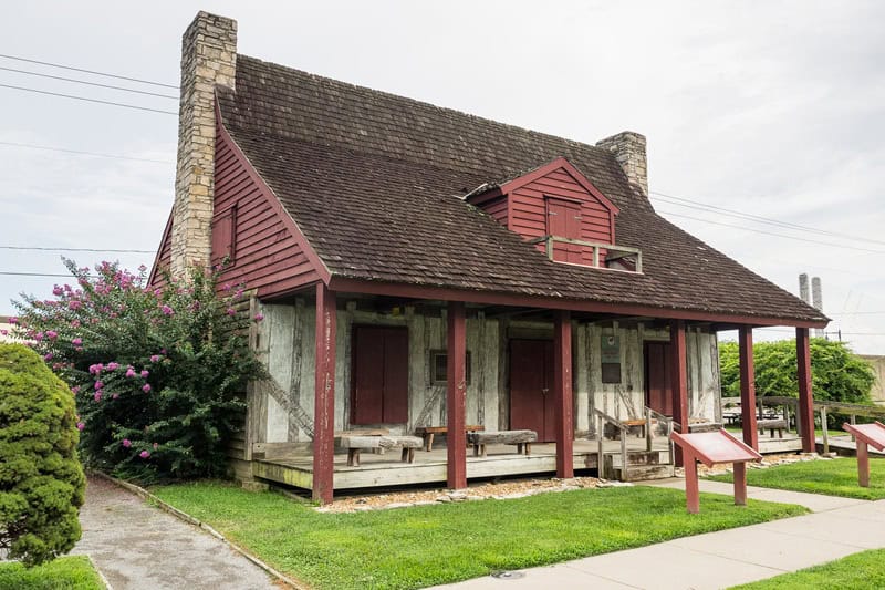
Red House Interpretive Center in Cape Girardeau, Missouri. (Mike Bezemek)
St. Louis Region
“This is a lot of stairs,” I said excitedly, as we joined other exercisers in an early morning ascent of Monks Mound.
“A lot of stairs,” muttered my wife, as we reached the top of the tallest earthen pyramid in the U.S.
Our reward was a panoramic view of Cahokia Mounds State Historic Site near Collinsville, Illinois. Built by Native Americans around a thousand years ago, Cahokia was once the largest city in North America, with a population estimated at 15,000. For uncertain reasons, the ancient site had long been abandoned when Clark visited the mounds in January 1804.
Clark had come from Camp River Dubois, which today has been recreated at the Lewis and Clark State Historic Site in nearby Hartford, Illinois. Stopping there next, we toured a small museum filled with maps and exhibits. Outside, there’s a replica of the wooden fort where the corps spent the winter preparing for departure.
Meanwhile, Lewis was often away from camp, procuring supplies or gathering information about the uncertain lands to the west. He was frequently seen at the territorial Cahokia Courthouse, which today is a rebuilt historic site. Or he was across the river in St. Louis. Since 1763, this growing fur-trade village had been controlled by the Spanish Empire. In the early 1800s, France had reacquired Louisiana and sold it to the U.S. to fund Napoleon’s wars. In March 1804, the Louisiana Purchase was officially completed. The Spanish flag was lowered. The French flag flew for a single symbolic day before the American flag was raised.
For our St. Louis base camp, we parked our travel trailer just outside the city at Babler State Park in Wildwood, Missouri. This put us within striking distance to visit friends and venture out to various Lewis and Clark sites. We used to live near Forest Park, so one day we walked around like the old days, ducking inside free attractions to cool off. The Missouri History Museum typically has a few rotating Lewis and Clark items on display at any time. Plus, many more Lewis and Clark exhibits can be found downtown at the free NPS Museum under the Gateway Arch.
North of the city, there’s a trio of Lewis and Clark sites. Fort Belle Fontaine, where the returning expedition spent its final night, is now an interpretive site inside a county park. Bellefontaine Cemetery has the grave of Clark, who died in 1838. And there’s the confluence of the Mississippi and Missouri rivers. Years ago, I kayaked there with friends, but either side can also be reached by roads and walking paths at suitable water levels.
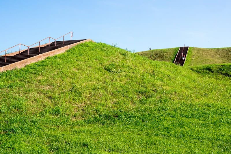
Monks Mound at Cahokia Mounds State Historic Site near Collinsville, Illinois. (Mike Bezemek)
St. Charles Riverfront
In mid-May 1804, the expedition launched from Camp Dubois, heading up the Missouri River toward the hilltop settlement of St. Charles. During this two-day shakedown, the corps shifted cargo to balance the barge and realized they needed more manpower to overcome the currents of this faster river.
My wife and I made a day trip to St. Charles before continuing west. We parked at the Lewis & Clark Boat House and Museum, which each summer hosts the finish line and post-race celebration of the MR340, the longest continuous canoe and kayak race in the country. Upstairs, we viewed displays and artifacts. Downstairs, we saw the replica barge and red-and-white pirogues that were used during the famous 2003-06 bicentennial reenactment of the Lewis and Clark Expedition.
The museum is also a good starting point for the Katy Trail. Due to a rising summer heat wave, we biked earlier that morning, going about 10 miles out before coming back, catching glimpses of the Missouri River along the way. Our favorite section continues out to Augusta and the surrounding wine region. We’d hoped to ride more of this fun gravel rail trail later in the week, but had to skip it due to the temps.
We finished our day by walking through the red-brick St. Charles Historic District to the town’s riverfront Lewis and Clark monument. Then we stepped inside for post-ride refreshments at the Bike Stop Café.
Back in 1804, after a final week of gathering supplies and enlisting crewmen, Lewis and Clark were ready. On May 21, the expedition departed upriver for what became a two-year adventure.
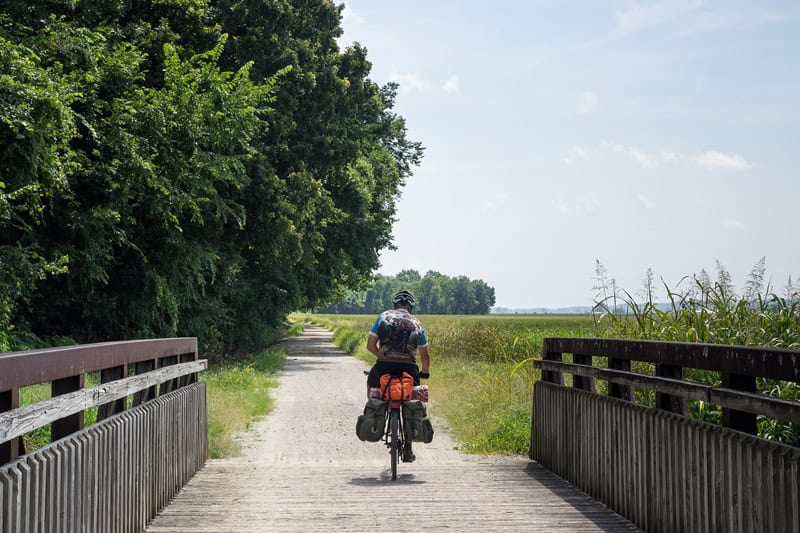
Biking along the Katy Trail near St. Charles, Missouri. (Mike Bezemek)
Along the Missouri River
Over 200 years later, my wife and I towed our camper west along Missouri Route 94, a rolling highway winding above and below the bluffs just north of the Missouri River.
Most retellings of the Lewis and Clark Expedition skip over the 10 weeks spent crossing the state of Missouri. One reason is that the Corps of Discovery’s first visit with Native Americans didn’t happen until reaching the Great Plains, where the Missouria and Otoe tribes spent the summer hunting bison. Another reason is that Lewis left no notes from these 10 weeks, limiting the information available.
However, the lower Missouri River is where the corps developed important skills that would take them to the Pacific and back. They quickly learned this wild river was harder to ascend than the Mississippi. On the Missouri, the boats encountered numerous braided channels, with islands, sand bars, rapids, and collapsing banks. Another obstacle was debris, including logs and driftwood piles racing downriver. The worst hazards were called sawyers, bobbing trees snagged in the muddy river bottom that could capsize the boats.
Problems happened on shore, too. Just a few days after leaving St. Charles, Lewis nearly fell to his death while exploring rocks above the entrance to Tavern Cave in present-day Franklin County. After sliding 20 feet, he plunged his knife into the slope, saving himself. While the riverside cave is not open to the public, several other sites can be visited.
In Jefferson City, after passing by for years, we finally toured the vast halls and exhibits at the Missouri State Capitol. Just outside of town, we hiked a half mile at Clark’s Hill/Norton State Historic Site to an overlook above a Lewis and Clark campsite.
Our base camp for two nights was Van Meter State Park, which mixes recreation and archeology. Located in the Pinnacles, the park protects the main village site of the Missouria tribe. Today, there’s a cultural museum, several earthen mounds, hiking trails, and more.
From here, we made a day trip to the hilltop village of Arrow Rock, Missouri. The name comes from a riverside bluff that yielded flint for Native American arrowheads. Lewis and Clark noted the spot when they came up the Missouri on June 8, 1804. Six years later, U.S. settlers established the frontier township. Today, the Arrow Rock State Historic Site includes a free history museum and guided walking tours of the historic district.
Before continuing west and visiting sites in Kansas and Nebraska, we found one more especially worthwhile Lewis and Clark site in Missouri. A half hour east of Kansas City, Fort Osage combines a comprehensive museum with a blufftop replica of a frontier trading post.
Fort Osage was established by Clark in 1808, two years after the Lewis and Clark Expedition. Waves of U.S. settlers were now spreading up the Missouri River and across the Louisiana Purchase, and the wild regions explored by the Corps of Discovery would never be the same.
***
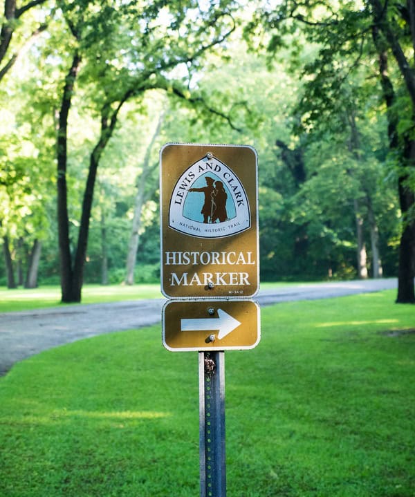
A Lewis and Clark Trail sign points the way. (Mike Bezemek)
Map the Expedition
A road-ready guide to Lewis and Clark-era landmarks.
Head south from St. Louis along the Mississippi River. On the Illinois side, check out Fort de Chartres and Fort Kaskaskia, both state historic sites. On the Missouri side, explore Ste. Genevieve National Historical Park, Red House Interpretive Center in Cape Girardeau, and the Ohio-Mississippi river confluence at Fort Defiance State Park.
Explore the St. Louis metro area. On the Illinois side, check out the Lewis and Clark State Historic Site (Camp Dubois), Cahokia Mounds State Historic Site, and Cahokia Courthouse. On the Missouri side, head downtown to the museum under the Gateway Arch. In St. Charles, check out the historic district, the Lewis & Clark Boat House and Museum, and the Katy Trail.
Head west along the Missouri River. Take Highway 94 to the State Capitol and Clark’s Hill/Norton State Historic Site in Jefferson City. Farther west, check out Van Meter State Park and Arrow Rock State Historic Site. If you’re headed to Kansas City, stop by Fort Osage.
For more ideas, check out the NPS interactive map of the Lewis and Clark National Historic Trail here.
Author: Mike Bezemek is a frequent contributor to Terrain.
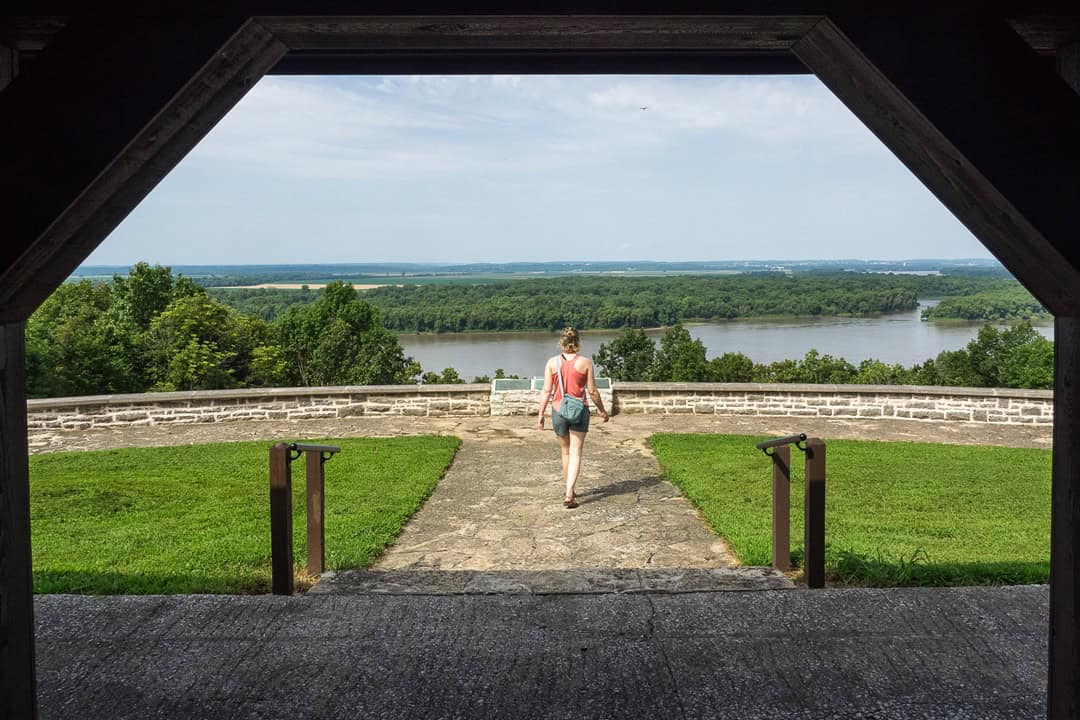
Top image: Fort Kaskaskia State Historic Site. (Mike Bezemek)
Leave A Comment