
I am usually a man of routine with little variation. However, within the span of a few weeks, that all changed. Last October, I turned 40, quit my job of 15 years (after receiving the blessing of my wife, Vara), bought a gravel bike, and decided to ride all 240 miles of the linear Katy Trail State Park. They say change can be good for a person, and I was about to find out.
I first became aware of the possibility of a thru-ride on the Katy Trail 20 years ago while attending college at Mizzou. Some friends and I would ride our bikes from campus, take the nine-mile gravel spur to meet up with the Katy near McBaine, and ride to Rocheport and back. We often passed dusty cyclists with their tents and sleeping bags lashed to their bikes. It looked gritty and like a proper adventure.
From then on, I romanticized the idea of bikepacking the entire Katy Trail.
For anyone unfamiliar, bikepacking is exactly what it sounds like — backpacking but on a bike. Instead of traversing the countryside by foot with all your necessities strapped to your back, you traverse the country with everything affixed to your bike.
Speaking of bikes, for quite some time, I had been eyeing a jack-of-all-trades gravel bike that could handle casual rides around town, the occasional race, and bikepacking the Katy, which is mainly made of crushed limestone and gravel. The day after I collected my last guaranteed paycheck, I drove to Red Wheel Bike Shop in my home of Jefferson City to officially make the bike mine. By the time I left the shop, I had secured not only my shiny new gravel bike but also two riding partners for the first half of the trip: Kevin, a seasoned bikepacker and mechanic at Red Wheel, and Ryan, a shop regular who, like me, had never bikepacked.
Day 1: Clinton to Pilot Grove (61 miles)
So, on a Sunday morning in late November, Vara graciously drove Kevin, Ryan, and me to Clinton to start our journey. We met in the Red Wheel parking lot at 7:15 and arrived at the Clinton trailhead by 9:30.
It was a warm, blue-bird day, and we couldn’t have been more stoked. We rang the small bell affixed to the Clinton kiosk, signifying the beginning of our trip east, and pushed down on the pedals.
After 90 minutes of riding, we had passed through the small trail towns of Lewis and Calhoun and arrived in Windsor, where we stopped at the trailside Casey’s General Store to refill our water bottles and buy something that would pass for a late breakfast. As I rummaged through my tube bag for my wallet, I realized my phone was gone, no doubt lying somewhere along the 16 miles of trail we had put behind us. (D’oh!) After a few choice words under my breath, I realized all there was to do was backtrack and hope that the phone had recently fallen and didn’t bounce into the endless bed of leaves that hugged either side of the trail, never to be seen again.
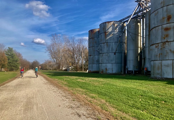
Passing grain silos on Day 1. (Kyle Wayne Stewart)
Luckily, Ryan spotted my phone lying on the trail four miles back. (Phew.) When we returned to Windsor, we stopped again at Casey’s, and I bought a round of tallboys as penance for my rookie mistake and the extra eight miles. (I also placed my phone in a zippered vest pocket so this wouldn’t happen again.)
Back on the trail, we passed the Katy-Rock Junction, where the Rock Island Trail connects to the Katy. At the spur, three bald eagles cleared the tree line to the north, circled overhead, and soared eastward, leading the way briefly before curling south.
Soon, we came upon a small mound to our left with a sign announcing a “High Point” on the trail with an elevation of 955 feet. We laughed, noting it felt just as flat as the rest of the trail. We stopped at our second Casey’s in Green Ridge for another liquid refill and then our third Casey’s in Sedalia for a late curbside lunch. Before leaving Sedalia, we stopped at the impressively restored Katy rail depot that serves as both a museum and welcome center. By then, the sun had already begun its rapid descent toward the western horizon.
We cruised past the towns of Beaman, Clifton City, and Pleasant Green, riding over railroad bridges and through head-high rock outcroppings, portending the bluffs yet to come.
Rolling into Pilot Grove City Park just past 6 p.m., we based our camp for the night around one of the park pavilions. I pitched my tent in the grass while Kevin and Ryan set up their inflatable pads and sleeping bags on the pavilion’s bare concrete floor. Then, it was time for food.
It being Sunday, the few cafes and diners in Pilot Grove were closed. However, we spotted yet another Casey’s three blocks away from the park, and it was open. (Clearly, Day 1 of our trip was destined to be the Tour de Casey’s.)
Back from our Casey’s raid, we sat at a picnic table, eating our sandwiches and washing them down with cold beers. The food was not gourmet, but we were happy to be eating and to be done pedaling for the day. As we were finishing up, we saw a flickering light heading toward us from the west. When the light got closer, I could make out an older man atop a recumbent bike pulling a homemade box trailer. He turned into the park.
“Afraid of the dark, I see,” the man said as he pulled up to our pavilion. We exchanged pleasantries. The man told us he had ridden across the country more than 15 times and was currently making his seventh pass through Missouri. If we wanted to know more, he said, we could Google “William Galloway biking” or “William Galloway brain injury.” With that, the stranger pedaled to the next pavilion over and was snoring within five minutes.
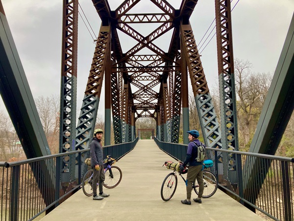
Stopping along the “Katy Bridge” in Boonville. (Kyle Wayne Stewart)
Day 2: Pilot Grove to Jefferson City (60 miles)
When we woke, Willam Galloway was gone. So was the pleasant booze-cruise weather of the day before, replaced by a biting wind and slate-gray sky. The temperature had dropped nearly 30 degrees and wouldn’t warm much above 40 the rest of the day.
We packed our sparse camp, yesterday’s sense of wonder and excitement gone with the good weather. It would be roughly 11 miles to Boonville, where we had planned to stop for breakfast, and we were eager to get going. A cold hour later, we rode past the River, Rails & Trails Museum and another restored train depot on our way to the famous “Katy Bridge.” Located west of the Isle of Capri Casino parking lot, the defunct lift bridge spans the Missouri River and is a structural marvel dating back to 1931, having been fought over by politicians and preserved largely thanks to legions of Katy Trail users.
We soon found the Main Street Diner, which is located catty-corner to the historic Hotel Frederick. Thankfully, it was open. We sat at a corner table, where we could keep an eye on our bikes, and each ordered a large breakfast and coffee.
As I paid the bill, our waitress asked how far we were riding. Her congenial manner changed to concern when I told her we still had 50 miles to go to Jefferson City.
“It’s too damned cold to ride a bike today, much less 50 miles,” she said. “Try to stay warm out there.” I promised we would do our best.
Back on the bikes, it would be hard to keep that promise. The wind whipped hard as we rode over the newer Missouri River bridge heading east toward Rocheport.
As we neared Rocheport, the landscape of open fields and big skies transformed into limestone bluffs, old-growth woodlands, and long stretches of trail paralleling the Big Muddy. We passed through the only railroad tunnel along the entire Katy and rode past a charming self-serve snack shack called Katydids on the Creek. There were several bed and breakfasts, including an old boxcar that had been converted into a guesthouse. We pulled off the trail at Meriwether Cafe to warm up before tackling the remaining 35 miles.
The Missouri River ran next to us most of the way from Rocheport to McBaine, where we peeled off-trail to make the short pilgrimage to the 400-year-old gnarled and lightning-ravaged Big Tree. This behemoth is tied for the title “largest burr oak tree in the country” and stands alone next to the road, surrounded by an expansive floodplain. We met back up with the river again five miles later outside Easley.
We pushed through Easley and into the gravel parking lot of Cooper’s Landing Riverside Resort, where smoke was rising from a firepit next to the camp store. We stopped to huddle around the fire, absorbing as much warmth as possible.
As we pulled away, streaked rays of sunlight escaped the heavy cloud cover. The last 20 miles flew by as we cruised into Jefferson City and returned to the bike shop where we had met the previous morning.
The first half of the trip was complete. It felt wonderful to be in my warm house, where I would sleep in my warm bed next to my warm wife with a belly full of warm food.
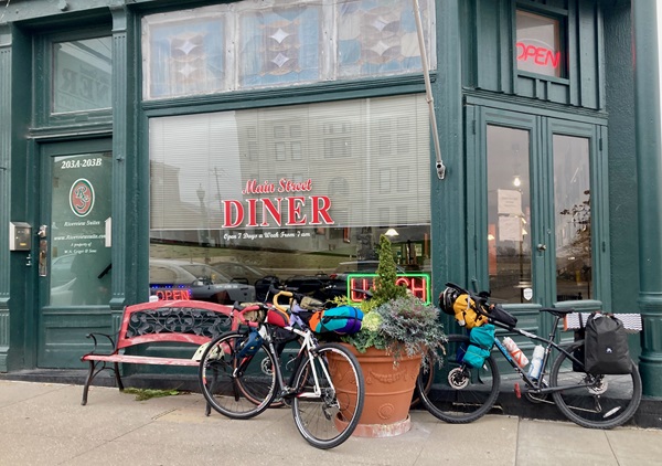
The Main Street Diner in Boonville. (Kyle Wayne Stewart)
Day 3: Jefferson City to Augusta (81 miles)
When I awoke on Tuesday, the frost was thick on the windshield of my truck. It was seven degrees below freezing. Going into the trip, I knew Day 3 would be the real test. It would be the coldest day of the week, the longest day in the saddle, and the first of two days I would fly solo.
While coffee brewed, I took stock of my gear and started eliminating everything I would not need for the next two days. With a forecasted nighttime temperature of 25 degrees, I opted for comfort over ruggedness and booked a furnished cabin in Augusta for the night. I dropped my tent, bike bags, sleeping bag, sleeping pad, camp stove, and propane. I planned to travel light and fast.
By the time Vara dropped me off at the North Jefferson trailhead at 8:30 a.m., it had only warmed to 30 degrees. To my surprise, I was not the only one there — a woman was bundled up and starting on a run as I pedaled east. She would be the last person I saw on the trail that day.
I thoroughly appreciated Kevin and Ryan’s company the first two days, but I also enjoyed riding by myself. I could go at my own pace, knowing that all I had to do was arrive in Augusta at some point that evening.
I made multiple stops throughout the bright morning to admire the bucolic countryside. Tebbetts had the Turner Katy Trail Shelter, a two-story hostel where cyclists can stay for $10. Mokane had towering grain elevators and an expansive horizon. Steedman, which used to be home to two SOBs — Steedman’s Only Bar and Steedman’s Only Bank — was a sleepy surprise with a large, mysterious standing rock along the trail (it looked like the molar of a giant humanoid). And Bluffton had the quaint Steamboat Junction Campground.
At McKittrick, I took the two-mile spur across the Missouri River into Hermann to get lunch. I stopped at the downtown Concert Hall and Barrel Tavern. Built in 1878, this eatery is the oldest continually operating tavern west of the Mississippi. After lunch and bottle refills, it was back to the dusty trail, Willie Nelson’s vagabond anthem playing in my head: “On the road again….”
I pushed through Case, Gore, Bernheimer, Treloar, and Peers. By the time I made it to Marthasville, the horizon was burning pink, and I had knocked out 70 of the day’s 81 miles. The last 11 miles were ridden in the dark, but there was a light at the end of the tunnel: I would enjoy pizza and beer at the trailside Good News Brewing Company in Augusta. Or so I thought.
When I arrived, the only lights to be seen were from my headlight and a few lonely street lamps. There was no sign of life throughout the town, and absolutely nothing was open. Dejected, I found my cabin for the night, grabbed a hot shower, and took inventory of my meager sundries: two granola bars, a package of Pop-Tarts, and a bag of sunflower seeds. I should have planned better. Instead, I had played a dumb game and won a dumb prize.
Day 4: Augusta to Machens (40 miles)
On the morning of the final day, I was moving slowly. Not only was I hungry, but I could feel the 200-plus miles on my legs and still had 40 miles yet to go. Within an hour, I was on the trail and heading toward St. Charles, where I knew I could get a hot meal. (I checked this time.)
The 27 miles went slowly, and I grew more frustrated with myself with each town I passed that didn’t offer food. I finally arrived at Frontier Park in St. Charles and made a beeline to the Bike Stop Cafe. I ordered a large breakfast and wolfed it down almost as soon as it was placed on the table in front of me. To keep with the thru-ride custom, I bought a celebratory can of beer to enjoy once I reached Machens.
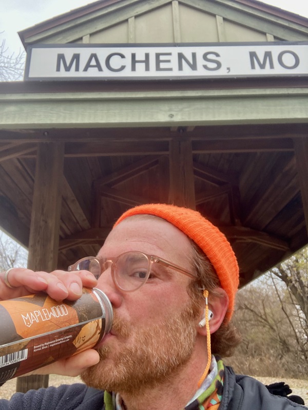
The author enjoying a celebratory beer. (Kyle Wayne Stewart)
Still overcast and chilly, the last 13 miles felt like a wasteland: open countryside without much to break up the scenery or the crosswinds.
Finally, I reached the lonely little outpost of the Machens trailhead. I found the small bell and rang the hell out of it, hoping that Vara, Kevin, and Ryan could hear it in Jefferson City. I cracked open my beer and drank deeply. It tasted like accomplishment. Like victory.
***
Riding the Katy Trail
Built on the former Missouri-Kansas-Texas Railroad (MKT) corridor, Missouri’s Katy Trail State Park is the longest developed rail trail in the U.S. It opened in 1990 and runs 240 miles through Missouri’s heartland from the western terminus in Clinton to the eastern terminus in Machens.
Katy Trail State Park is free and open year-round from sunup to sundown. The official brochure from Missouri State Parks is available at every trailhead and lists the services in each trail town (e.g., camping, food, restaurants, groceries, bike shops with bike repair, etc.). The Missouri State Parks website also offers detailed information on services at each trailhead.
Camping is available and free at some trailheads and city parks, but it’s recommended that you call the local police station and let them know you will be staying there so police officers don’t roust you in the night. Many guesthouses and privately owned campgrounds along the trail (as well as cafes, breweries, and wineries) are available, too. State parks close most trailhead bathrooms and shut off water spigots from November 1 through April 1.
If you’re preparing to ride the Katy, research the towns you plan to stop in. Find out what’s open and what’s not and proceed accordingly. Also, be proactive with hydration and fueling. A good rule of thumb is one energy bar and one bottle of water per hour.
***
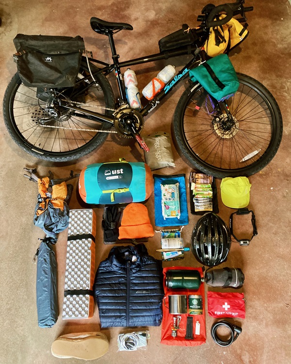
Preparation is crucial for a successful Katy Trail thru-ride. (Kyle Wayne Stewart)
What to Bring
What kind of bikepacker are you? I brought the following items on my Katy Trail thru-ride but could have gone without some (represented with an asterisk).
Bike
Helmet
Tire repair kit (patch or plugs, spare tube, tools)
Tire pump
Water bottles
Vaseline (Chamois Butt’r also works)
Bike bags and dry bags
Bungees and straps
Sleeping bag
Sleeping pad*
Sleeping clothes
Headlamp
Toilet paper and wet wipes
First-aid kit
Toothbrush, toothpaste
Deodorant*
Snacks (granola bars and energy bars)
Charging brick and charging cord
Tent*
Camp shoes*
Mini camp stove and propane canister*
Instant coffee*
Extra set of riding clothes*
Author: Kyle Wayne Stewart is a frequent contributor to Terrain.
Top image: Riding the Katy Trail toward Jefferson City. (Kyle Wayne Stewart)
Leave A Comment