The new bridge connecting the River des Peres Greenway in South St. Louis to Grant’s Trail on the Gravois Greenway is the latest in Great Rivers Greenway’s 20-year journey to deliver on what people in the region have asked for and voted to fund.
“It is the number one most requested project in our system,” said Susan Trautman, CEO of Great Rivers Greenway.
The connection opens up 22 continuous miles on the two greenways, from the River des Peres in Shrewsbury and Grant’s Trail in Kirkwood to a new bridge in Lemay south of I-55. From these greenways, you can picnic or fish in Carondelet Park, throw a frisbee on the Willmore Park disc golf course, visit the Ulysses S. Grant National Historic Site, catch a ride from the Shrewsbury Metrolink Station, and get to more parks, neighborhoods, and businesses in southern St. Louis City and County.
A 2-mile extension of the Gravois Greenway, from the Mysun Charitable Foundation Trailhead near Orlando’s along the I-55 right-of-way to River City Boulevard, was a key piece in creating the connection. Ten years in the making, the $14 million project features a 600-foot bridge over Bayless Avenue, a tunnel under Weber Road, a recycling hub, and a restored wetland in a former industrial area. A bump-out on the boardwalk over the wetland provides space to pull over, watch for wildlife, and see the natural renewal in progress.

Boardwalk on the new section of Gravois Greenway: Grant’s Trail. (Janice Branham)
“This is such a great example of turning a neglected site into something that is going to be a wonderful habitat for wildlife, for children to learn, and for people to just come and find some rest and quiet and beauty. It will get better every year as nature does its magic and restores this land,” said Carol Klein. She and her husband, Ward Klein, were among many private donors who matched a grant from the Mysun Charitable Foundation that helped fund the project.
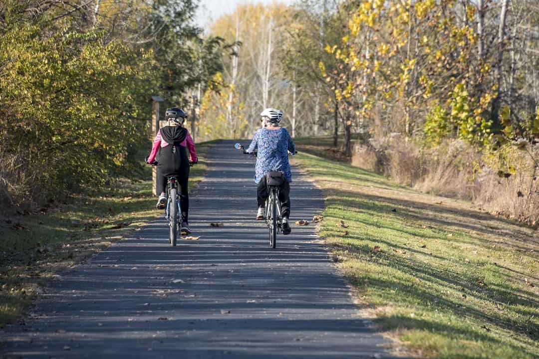
The Gravois extension is a game-changer for cyclists like Kelly Hogan, who used to ride 40 miles on the roads every weekday, from the Soulard neighborhood to her job in Crestwood.
“When the new section opened up at River City Boulevard, I tested it out and loved it,” Hogan said. “I prefer being away from the cars. I like seeing all the families walking and riding together. There is a sense of community on the greenway — much better than driving to work in your car.”
It Started with St. Louis 2004
That sense of community, along with the neighborhood connections and environmental improvements along the Gravois Greenway extension, exemplify what thousands of area residents hoped for when the greenway system was conceived more than 20 years ago.
In the late 1990s, more than 10,000 citizens participated in public engagement sessions for St. Louis 2004, a nonprofit organization with a mission to bring about a renaissance in the bi-state region. As the 100th anniversary of the World’s Fair in St. Louis and the 200th anniversary of the Lewis and Clark expedition to explore the Louisiana Territory, 2004 was a rallying point for bringing people together to identify improvements that would benefit everyone in the region.
Shaughnessy Daniels, now a community engagement manager for Great Rivers Greenway, was part of the St. Louis 2004 team that fanned out across 12 counties in 1996 to talk to people at fairs, festivals, and forums about their hopes and dreams for the region’s future.
“This was a grassroots effort to ask, ‘Where should we be in 2004 and how should we get there?’” Daniels said. “People wanted cleaner air and a healthy environment. They loved their parks but saw that there was no system to link them all. They talked about making our neighborhoods safe and healthy and connecting our communities. Parks and trails were the pathway between all those things. It connected the dots.”

Citizens have guided the priorities, look, and feel of the greenways from the beginning.
Those aspirations became part of the vision for St. Louis 2004. To move the vision forward, six volunteer action teams created plans addressing such issues as access to health care, racism, gang violence, downtown revitalization, sustainable neighborhoods, jobs, and minority business growth.
A Parks and Open Space Task Force studied the region’s environmental needs. Robert Hall, then director of St. Louis County Parks and Recreation, led the group in studying the opportunities for the region’s parks, trails, and flood plains. Ted Curtis, who led Trailnet’s effort to build the first six miles of Grant’s Trail in 1996, proposed the development of a network of greenways along the region’s rivers. Mark Vogl, now a project manager at Great Rivers Greenway, worked as a consultant for HOK to develop a concept for the network.
“At the time, the goal was to create 200 miles of bike trails,” Vogl said. “In community engagement sessions, people said there’s no need to stop there. What we really need is not just bike trails but more open space and an overall effort to improve quality of life. It elevated the idea from a bike trail concept to a greenway, park, and open space concept.”
The task force developed a vision for a greenway system that would protect rivers and watersheds, preserve open spaces and wildlife habitat, and expand parks and trails for the public’s safe use and enjoyment. The proposal became part of the final St. Louis 2004 Action Plan in 1998.
Two years later, after legislation passed in Missouri and Illinois authorizing tax districts to finance the greenways, the proposal came before the people for a vote. Peter Sortino, president of St. Louis 2004, spearheaded the campaign for Proposition C: The Clean Water, Safe Parks, and Community Trails Initiative. A one-tenth of one percent sales tax would generate more than $20 million each year in Missouri to develop the greenways and improve local parks. Sortino and Hall met with people at churches, schools, and civic organizations in seven counties where the question was on the ballot.
“This was apple pie and motherhood,” Hall said. “The whole idea connected with everyone.”
On November 7, 2000, Proposition C passed by a landslide in St. Louis City and St. Louis and St. Charles counties with 68 percent of the vote, resulting in the creation of Great Rivers Greenway. In Illinois, the people of Madison and St. Clair counties approved Proposition C to create the Metro East Park and Recreation District.
Building the Greenway System
Twenty years in, Great Rivers Greenway continues to engage the public in its mission to make the region a more vibrant place to live, work, and play. In 2004, the organization published “Building the River Ring: A Citizen-Driven Regional Plan” envisioning 600 miles of greenways along the area’s mighty rivers and streams. So far, the organization has built 128 miles of trails with local input on the alignment and amenities for each project.
Trojan Park in Wellston on the St. Vincent Greenway is an example of how public engagement has led to better plans.
“The neighbors who served on the Trojan Park group really determined a lot of the decisions about the park,” said Emma Klues, vice president of communications and outreach at Great Rivers Greenway. “What they saw in photos during the planning literally came to life because they said, ‘We like this type of thing.’ There are some swings in the park with an adult and child seat facing each other. We have a lot of kids and grandparents hanging out together there, and intergenerational play is important to them.”
Built with support from the National Recreation and Park Association’s “Parks Build Communities” initiative, Trojan Park draws an estimated 20,000 annual visitors to enjoy the splash pad, basketball court, playground, picnic area, shady seating, and community events like the Juneteenth Festival. In September, it received the 2020 Urban Open Space Award from the Urban Land Institute, recognizing its impact to promote healthy, sustainable, equitable outcomes.

Adults and kids of all ages enjoy Trojan Park on the St. Vincent Greenway.
“Often in a lower income community, we don’t expect the best to happen,” said Monica Huddleston, a board member who enjoys walking on the greenway in St. Vincent Park. “People get excited when they see how nice it is.
“Having safe trails that are separate from the streets is important for us,” she continued. “There’s a lot of opportunity for input, and [Great Rivers Greenway] build it according to what you said you wanted. That is what people are most impressed with.”
The greenways have been even more valuable during the COVID-19 pandemic, as breathing space for people to nurture their mental, physical, and emotional health. Trail use has jumped by 52 percent in the first half of 2020 compared to the same period in 2019.
“Some folks have told us this was great because they could get some alone time out of the house. Others say this is the only time they get to connect with other people, even if it’s from a distance,” Klues said.
As the challenge of maintenance has grown with the network, citizens are a valuable force to sustain the greenways. Last year, volunteers provided 30,000 service hours through trash bashes, invasive species removal, planting days, and public events.
Great Rivers Greenway’s Citizen-Driven Regional Plan is due for a five-year update in 2021 to shape the direction for the next 20 years. The public will be invited to weigh in on priorities soon through online surveys and interactive maps.
In the meantime, here is a look at some of the active projects planned over the next five years.
Mississippi to River des Peres Connection
The southern section of the Mississippi Greenway runs from Jefferson Barracks Park north to the River City Casino. A long-awaited, half-mile connection from the casino to the River des Peres Greenway at Broadway has been on hold while MSD completes sewer line improvements. Work is moving forward, and the connection could be done as early as spring 2021.
Deer Creek Greenway
This greenway runs from Lorraine Davis Park in Webster Groves to Deer Creek Shopping Center in Maplewood. Plans are in development for a 1-mile extension east through Maplewood to meet the River des Peres Greenway near Francis R. Slay Park. On the west side of the greenway, a connection from Marshall Avenue will continue north through Brentwood, running below Manchester Road on an underpass to meet the Rogers Parkway trail.
St. Vincent Greenway
A 3-mile gap on this greenway from Trojan Park to St. Vincent County Park is set to be closed over the next three years, completing the 7-mile route from UMSL to Forest Park. Construction starts late this year on the next segment from Trojan Park past the Wellston Metrolink station to the former Eskridge High School. A future segment will go by the Pagedale Town Center.

St. Vincent Greenway on the UMSL campus.
“Pagedale has done a lot of redevelopment in the last five years” said Todd Antoine, chief of planning and projects for Great Rivers Greenway. “They’ve been fun to work with because they’re trying to see how the greenway can connect some of that development and tie into the Wellston and Rock Road Metrolink stations. We’re trying to leverage the greenway to connect people to job opportunities.”
Maline Greenway
The next segment of this route through North County will go from the Ted Jones Trail in Ferguson east along Maline Creek to the Ferguson Community Empowerment Center on West Florissant. Construction is slated to begin in late 2022.
Centennial Extension to Olivette
Currently in the design phase, this project will extend Centennial Greenway from I-170 at Olive Boulevard through Olivette to Indian Meadows Park and Warson Park. It sets the stage for a future connection to the Danforth Plant Science Center at 39 North in Creve Coeur. The plan factored into the decision by KWS, a German seed company, to open a research center at 39 North.
“They called to find out when the greenway would connect there because bikeability and walkability were a big part of how they wanted to choose their location,” said Klues.
St. Charles County
Construction is slated for 2021 to 2022 on an extension of the Centennial Greenway from the bridge over Highways 364 and 94 along Old Highway 94 to Schaefer Park. A future segment will continue to the St. Peters Rec-Plex, connecting all the way to the Katy Trail at the Page Bridge.
“Everybody wants interconnectivity,” said Jennifer George, assistant director of administration for St. Charles County. “People love being able to tie to the Katy Trail and go long distances.”
The work is part of a broader master planning process to prioritize new connections between the Boschert, Busch, Centennial, and Dardenne Greenways in St. Charles County. More than 1,000 people weighed in this year in a survey about nine possible alignments. Final recommendations will be published late this year.
Brickline Greenway
When a plan for the Chouteau Greenway from Forest Park to downtown St. Louis picked up steam three years ago, city residents made it clear they wanted the project to be more inclusive and equitable. Renamed the Brickline Greenway to reflect what the city has been built on for hundreds for years, the project will transform St. Louis through a 20-mile network of trails connecting north and south neighborhoods as well as the central corridor. More than a trail where people can exercise and commute, the project aims to create economic opportunities for everyone.
Dennis Lower, who served as CEO of the Cortex Innovation Community for 10 years, sees the potential for the Brickline Greenway to be a catalyst for economic growth.
“There’s no question that bike-ped trails are a positive influence for company site selection decisions,” Lower said. “Quality of life issues will be more important for employees, and as a result, for their employers. This will be a major draw in the city because it’s an outdoor recreational environment that’s at your fingertips. I’m optimistic that it will have a very positive impact in helping to rebuild neighborhoods that have been neglected.”

Draft Concept for Brickline Greenway’s public art project by Damon Davis honoring Mill Creek Valley.
Plans are moving forward for three initial segments. A trail from Fairground Park south to the Grand Metrolink station and east to the NGA is in the public engagement stage. Another segment from the Central West End to the Grand station is in planning and design. A third segment from Harris Stowe State University to the new MLS soccer stadium will feature a public art project to honor Mill Creek Valley, a thriving black neighborhood that was erased in the 1950s to make way for highway construction.
Damon Davis, a multi-media artist, musician, and lifelong St. Louis resident is designing the project near Union Station to remember this community. The concept features hourglasses that hold the soil where the people of Mill Creek Valley lived, suspended in time and space.
“Art that produces a space that is welcoming allows people to have social gatherings where people connect, where people actually start to see that they’re not that different from each other,” said Davis. “I think art on this greenway should do just that because the greenway is not just downtown; it’s up on the north side, it’s south, it’s west. I think everybody in the community can get a little piece of that.”
Author: Janice Branham is a regular contributor to Terrain Magazine.
Leave A Comment