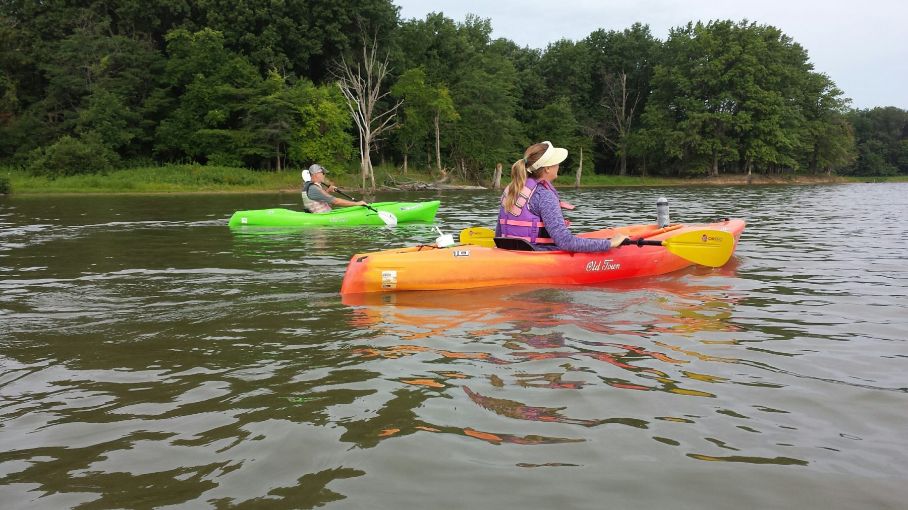
Summer is back, and that means so is paddling season! In Missouri, we’re blessed to have the country’s first nationally protected wild river system, the Ozark National Scenic Riverways, which consists of the Current and Jacks Fork rivers and their 134 miles of clear, free-flowing, spring-fed waterways. Floating here is truly as good as it gets.
The only problem is, unless you live close by in the southern part of the state, it’s not always possible to make a day trip or weekend escape when you need to feed your canoeing or kayaking fix. So, in effort to broaden our paddling horizons, we’ve scouted seven options close to St. Louis that even the most avid outdoorist might have overlooked.
Read on, then grab your paddle, your PFD, and your watercraft and join us on a new adventure.
Horseshoe Lake, Illinois
(Mark Nettles)
Located 10 minutes from downtown St. Louis north of Interstate 70 in Granite City, Illinois, Horseshoe Lake is a natural wonder. A former bend in the Mississippi River, this 2,400-acre oxbow lake is the second largest natural lake in Illinois (after Lake Michigan) and has been recognized by the federal government as a National Natural Landmark. This means it’s protected — in fact, it’s now the main attraction at Horseshoe Lake State Park — and is preserved as an outstanding example of the area’s biodiversity and natural history.
For the most part, Horseshoe Lake is very shallow; the majority of it hovers between 3 and 4 feet in depth year-round (save one section that reaches a depth near 54 feet due to past dredging). This predominantly thin depth makes it a haven for waterfowl of all types and sizes, including Canadian geese, mallard ducks, snowy egrets, and little blue herons. Bald eagles are often spotted wintering along the 20 miles of shoreline here. For anglers, fish species include bluegill, sunfish, gar, crappie, bass, and channel catfish.
The flora surrounding Horseshoe Lake is impressive as well. Bald cypress, tupelo gum, and swamp cottonwood trees are reminiscent of swampland typically found much further south. Red buckeye shrubs burst forth in April, wild lotus flower in June. Fall brings a menagerie of color as the foliage changes to red, yellow, orange, and purple.
There are two boat ramps in the park, plus plenty of shore access points. Paddlers also have the opportunity to camp overnight from May 1 to September 30 (no reservations required), with options ranging from basic to full electric and trailer sites, served by a dump station and pit toilets nearby.
Note: Horseshoe Lake State Park is connected to Madison County Transit’s bike trail network via the Schoolhouse Trail, providing access to the 130-mile (plus) MCT Trails system. Bring your bike and create your own pedal-and-paddle tour.
Piasa Creek, Illinois
(Dean Klinkenberg)
Paisa Creek is typically well off the radar for even the most experienced local paddler. A minor tributary that drains directly into the Mississippi River, the stream is one of those hidden secrets that most people “in the know” are reluctant to share. (Sorry, guys and gals.)
Located in Jerry County, Illinois, just west of Godfrey in the unincorporated community of Lockhaven, Piasa Creek has a public boat ramp located near where the creek empties into the Mississippi. Immediately before crossing the creek on the Great River Road/McAdams Parkway, turn left on Hazelnut Lane — you’ll find a parking area and the boat ramp at the south end of the lot. Alternatively, Piasa Harbor is just across the creek and has dock access if that is preferred.
Once on the water, paddlers are presented with two distinct choices: head upstream to investigate the reaches of the creek as it winds its way away from the Mississippi, or head out into the big river, where Piasa Island and other seasonal islands form a back channel worthy of exploration.
For those heading out onto the Mississippi, it’s best to stick to the shoreline and back channels, as this stretch of the river is north of the Chain of Rocks Canal and thus frequented by barges, towboats, and other commercial river traffic. Venturing into the main channel can be risky without a marine radio and proper knowledge of river signage, etiquette, and protocol.
For a quieter, more peaceful paddle, head upstream and take in the bends of Piasa Creek as it wanders through the Illinois countryside. Rolling farmland, secluded woodlands, and creek-side bluffs highlight this trip. Paddle as far as you like, keeping in mind your return to the boat ramp will be a bit quicker as you go with the flow.
Carlyle Lake, Illinois
Just 50 miles east of St. Louis, Carlyle Lake offers activity-filled days spent outdoors followed by nights around the campfire or in a nearby cabin or cottage.
In the late 1950s, the federal government began purchasing tracts of land in Illinois as part of a flood control program, ultimately damming the Kaskaskia River in 1967. The result was this 26,000-acre manmade reservoir — the largest in the state — which is surrounded by 11,000 acres of undeveloped land.
Highlighted by Eldon Hazlet State Park and the Carlyle Lake Wildlife Management Area, Carlyle Lake is ripe with opportunities for paddlers of all types and skill levels. A water trail (pick up a map at the visitor center) identifies 11 coves and other features ideal for kayaking, canoeing, and paddleboarding and provides entry points, paddling distances, difficulty ratings, descriptions and lat-long coordinates.
There are five developed campgrounds around the lake, which combined support over 400 sites. In addition to campgrounds, hotels and lakeside cabins are available. There are five beaches and several boat ramps — easy access for getting your watercraft onto and off of the lake.
Eldon Hazlet State Park is the largest designated recreational area on the lakeshore. It’s located on the western shore of Carlyle Lake, three miles north of the town of Carlyle. This park hosts over 800,000 visitors annually, with outdoor enthusiasts coming to fish, camp, boat, and relax along the lakeshore.
Lake Carlyle is especially popular for sail boats, a steady breeze being typical year-round. Sailing regattas are common during the summer, especially on the weekends.
To get to Carlyle Lake, take Interstate 64 east into Illinois and through O’Fallon. On the east side of O’Fallon, take State Highway 50 East to Carlyle, which is at the southern end of the lake. You can also download the Carlyle Lake App from the App Store for iPhone or Google Play for Android users.
Lake Lou Yaeger, Illinois
An hour’s drive north of St. Louis on Interstate 55, paddlers will find yet another often-underutilized opportunity to explore new shorelines. Just east of charming Litchfield, Illinois, lies Lake Lou Yaeger, a 1,357-acre, 5.5-mile-long body of water that marks the centerpiece of the area’s growing outdoor culture.
One of the best put-in spots is Milnot Beach, a public swimming beach that has volleyball courts, restroom facilities, a snack bar, and picnic tables, along with plenty of room for relaxing with your toes in the sand. Milnot Beach is open to the public from Memorial Day to Labor Day, with kayaks, Corcls, and stand-up paddleboards available for rent to those who aren’t able to bring their own. Anyone with an Illinois Fishing License can cast for crappie, catfish, bluegill, and annually stocked bass.
Along the eastern shore of the lake, Shoal Creek Conservation Area is a highlight for nature lovers. It’s one of the best remaining examples of native oak and hickory woodland environments in all of Illinois — a must see for environmental enthusiasts. Lake Lou Yaeger is home to 700 plant species, 70 butterfly species, and more than 70 bird species, in addition to deer beaver and the occasional otter. Paddle along the quiet shoreline and take in the serene tranquility of one of the most beautiful spots in all of Illinois.
Lake Lou Yaeger is a public, City-owned facility, which requires all boaters to purchase a pass to put-in here. Day/annual passes for canoes and kayaks are available at Marina 1, north of Milnot Beach on Beach House Trail.
Ellis Bay, Missouri
(Bob Virag)
If avian encounters are your thing, it doesn’t get much better than paddling Ellis Bay at Riverlands Migratory Bird Sanctuary in West Alton, Missouri. And even if bird-watching doesn’t necessarily float your boat, a quiet cruise around the bay is an incredibly peaceful, uniquely St. Louis wildlife experience.
Unbeknownst to many locals, the area’s Great Rivers serve as superhighways for annual North American bird migrations. Every year, tens of thousands of our migratory feathered friends make their way through St. Louis, the sprawling confluence of the Missouri and Mississippi rivers being a natural rest stop for these long-distance travelers. Herons and egrets, American pelicans, Canadian geese by the thousands, trumpeter swans, bald eagles, falcons, kestrels and harriers; in all, more than 300 species visit these wetlands every year.
Ellis Bay constitutes a small section of this vast wilderness, providing paddlers incredible opportunities to view these birds in their natural habitat. The most direct access from St. Louis is via State Highway 67, north off Interstate 270, though many people choose to drive the Great River Road (State Highway 3) on the Illinois side of the Mississippi and cross over the 67 bridge in Alton, Illinois.
There’s a boat ramp located at the end of Riverlands Way at the Maple Island access, but shore access points abound all along the riverfront. In addition to Ellis Bay, paddlers can explore the smaller wetlands of Heron Pond, Dragonfly Marsh, and Two Pecan Pond. Wherever you choose to put-in, you can’t go wrong — waterfowl and wildlife abound throughout the area.
The Audubon Center at Riverlands Migratory Bird Sanctuary is a local treasure, focusing on educational programs, conservation efforts, and opportunities to link residents to the beauty and significance of the Great Rivers. Learn more about their work at riverlands.audubon.org.
Loutre River, Missouri
(Matt Green)
Winding its way through the rolling hillsides north of Hermann, the Loutre River is a hidden gem of east-central Missouri. Named by French traders for the otters frequently seen in its waters (“loutre” is French for otter), this 58-mile tributary of the Missouri River has long been a resource for locals, playing a key role in trade, transportation, and the recreational development of the area.
One of the main attractions and put-in points along the Loutre River is Graham Cave State Park. This 386-acre park is loaded with history; artifacts found inside the cave hint at it being inhabited nearly 10,000 years ago. More recently, the area has been developed into a haven for hikers, cyclists, campers, anglers, and paddlers.
For those wishing to explore the Loutre via Graham Cave State Park, they can access the river by way of the paved boat ramp located at the south end of the park. It’s open daily from 7 a.m. to sunset. Note that it is seasonal; the ramp is closed between December 2 and March 15.
From the boat ramp, it’s an easy paddle upstream, exploring along the reaches of the river. The Loutre reaches roughly 40 feet at its widest point, narrowing to 12 feet in its tightest sections. At low water level, there’s hardly a flow to be noticed, and paddling against the current is easily managed. Enjoy the beauty and serenity of a quiet, secluded, off-the-beaten-path paddle in the middle of the Missouri wilderness, just minutes off Interstate 70.
Graham Cave State Park is located west of Danville on the north side of Interstate 70. Heading west, take Exit 170 at Danville and then continue west on Highway TT, following signs to the park’s entrance.
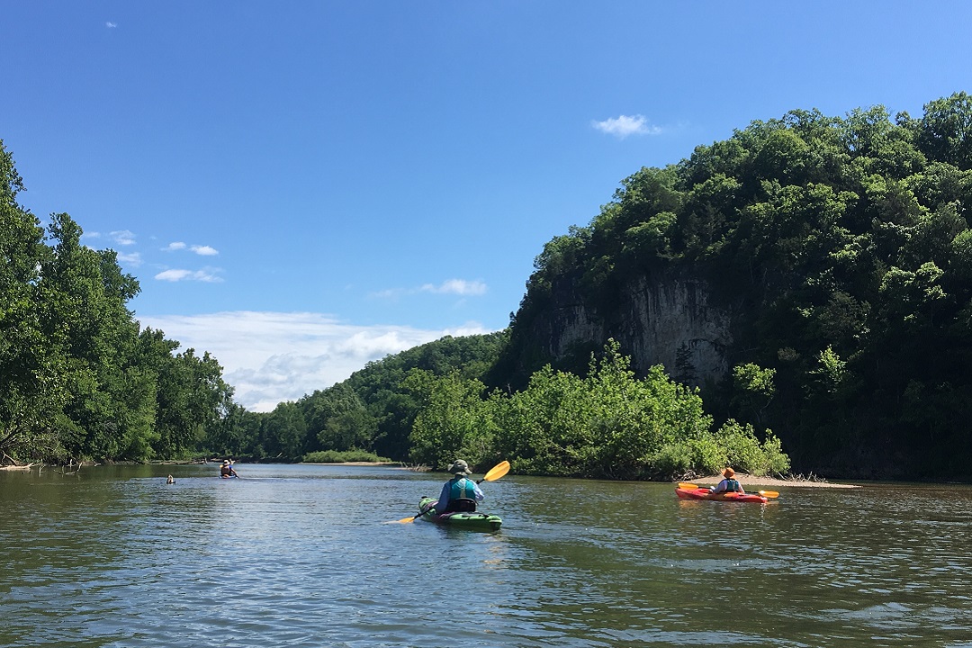
Lower Meramec River, Missouri
(Barbara Gibbs Ostmann)
When talking rivers around St. Louis, the Meramec is mentioned nearly as routinely as the Mississippi and the Missouri. While not as large as the area’s two Great Rivers, the former does offer an abundance of local paddling prospects that often go underappreciated.
One of our favorite stretches of the Meramec runs from Pacific Palisades to the Allenton Access ramp in Eureka. This 7-mile downstream paddle highlights some of the best scenery the meandering waterway has to offer. Natural Missouri riverland beauty, easy access, a fun balance of minor rapids and cruisy flat water, interesting rock formations and rolling hillsides, plenty of gravel and sand bars to explore along the route — all that and more wait just minutes west of St. Louis on Interstate 44.
Another reason we like this paddle so much: It’s an easy self-shuttle with two vehicles. You’ll want to drop the vehicle without the boat(s) at Allenton Access ramp (the take-out point). To get to the parking area, exit I-44 at Allenton/Six Flags Road and turn south under the interstate. Go straight through the light and up and over the railroad tracks, heading east on Allenton Road. Turn right (south) on Hunters Ford Road and continue to the Meramec River access. Once you’ve dropped a vehicle there, it’s time to head to the put-in point.
The put-in is at Pacific Palisades Conservation Area boat ramp. To get there, retrace your path back towards I-44. After crossing the train tracks, turn left at the light onto Business Loop 44, then head west to Dozier Crossing. Turn left (south) across the railroad tracks and follow signs on Franklin Road to the river access point. Once there, get your boats on the water and enjoy a day of smooth water and calming atmosphere.
Before you go: The Meramec is a spring-fed river, meaning there’s typically plenty of water for paddling. That said, it’s always a good idea to check the current and forecasted water levels before setting out on any paddling trip. Check water.weather.gov for up-to-date information.
Author: Nick Tilley is a regular contributor to Terrain Magazine.
Top Image: Meramec River paddle by Barbara Gibbs Ostmann.
Leave A Comment