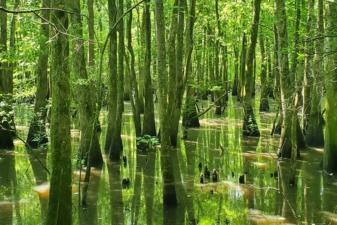
My husband John and I walk at a leisurely pace down a gently sloping path through thick upland woods, cross the fast-flowing brown water of the Cache River, then stride alongside the stream through a healthy bottomland forest. After a mile of fending off swarms of mosquitoes hungry for a meal, the trail detours down a floating boardwalk that zigzags through a lush cypress-tupelo swamp that smells sweetly of pine. This swamp is home to river otters and prothonotary warblers, but not alligators. That’s because this swamp, Heron Pond, spreads out in Southern Illinois instead of Louisiana, just 150 miles southeast of St. Louis. And all it takes to experience the wonders of a real swamp is a short hike on the Todd Fink-Heron Pond Trail.
Southern Illinois is full of surprises, and the Cache River Basin is one of its best. Those cypress-tupelo swamps are a good part of the reason; you won’t find them any farther north. The Cache River has much more to offer besides one hike, though. You’ll also find a paddling trail, ancient cypress trees, multiple hiking trails with varying levels of difficulty, a state bike trail, and a lot of places to feel far removed from the rest of the world. And best of all, it’s an easy trip from St. Louis, whether you want to go for a day or longer.
A Deep History
A few thousand years ago, the Ohio River carried glacial meltwaters along the course where the Cache River runs today. The Cache River Watershed covers some 500,000 acres in an ecologically diverse area that includes rock outcroppings of the Ozark Plateau, floodplain forests, and cypress-tupelo swamps.
The area has a deep human history, from indigenous people who lived and traded in the area for centuries to French fur traders to more recent Euro-Americans. Logging and farming in the early 20th century dramatically altered the area. About half of the basin used to be swamps and wetlands, but just 10 percent of those swamps remain today.
The Cache originally flowed nearly 100 miles through Southernmost Illinois to the Ohio River. In 1916, the U.S. Army Corps of Engineers built a diversion canal called the Post Creek Cutoff that divided the Cache River into upper and lower sections. Later modifications included a levee and another canal to divert water to the Mississippi River. The cumulative effect has been the clearing of wetlands for farming and other uses.
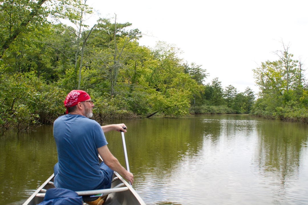
Paddling through the Cache River. (Dean Klinkenberg)
Much of what’s left is now protected in a mix of state and federal refuges. Illinois manages Cache River State Natural Area, while the federal government manages Cypress Creek National Wildlife Area. Conservation efforts have gained momentum, though, and wildlife managers are coordinating with many local landowners to restore the natural features of the area. In addition, a plan has been on the books for a while to reconnect the Upper and Lower Cache River, although it’s not clear when that might happen. The state and federal conservation areas consist mostly of scattered parcels that spread across the basin rather than a single park. You’ll need a car (or a bicycle) to visit them.
A good place to start any visit is at the Barkhausen Wetlands Center south of the village of Cypress. Inside, you can watch a short video with a history of the Cache River Basin, plus grab plenty of maps and brochures to help you find your way around. Outside, you can wander or bike the paved trails that wind through restored wetlands and prairies. The rest of the trails in the state and federal refuges are open to hiking only.
If your goal is to see as much wildlife as possible, your best bet is, as always, to go early or late in the day. Find a good viewing area, settle in, and watch for a while. This will increase your chances of seeing something other than a squirrel or a few red-winged blackbirds.
The Upper Cache
Attractions along the Upper Cache run roughly northeast of the village of Karnak toward Vienna. The star attraction is the remaining sections of cypress-tupelo swamp, which spread out over land that was coastal plain a few million years ago. The most accessible way to reach the thicket of the swamp is along the aforementioned Todd Fink-Heron Pond Trail. You’ll hike through the thickest air this side of Louisiana. Bring bug spray if you’d like to linger as you traverse the trail. John and I hiked it after a couple of days of rain, and the wide gravel path was dry and lined with dozens of mushrooms. The shortest route from the parking lot to the boardwalk and back is 1.5 miles. When you reach the fork in the trail, go left to the boardwalk or stay right to check out Illinois’ largest cherrybark oak.
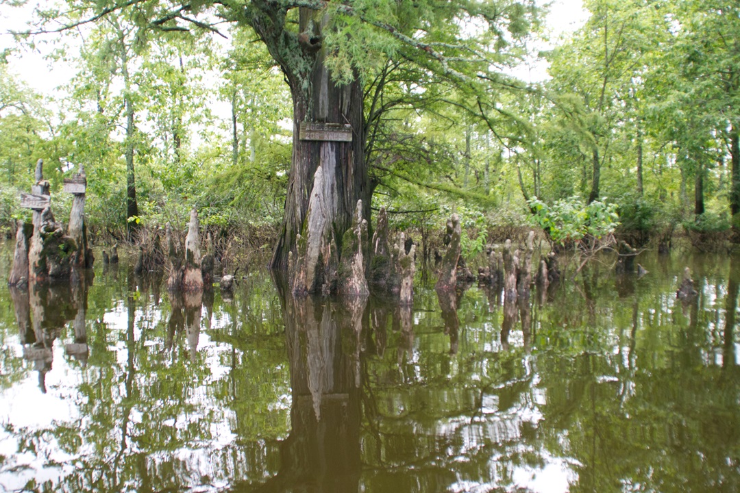
A very swampy area of the Cache River. Pro tip: Don’t swim here. (Dean Klinkenberg)
At Wildcat Bluff Access, there’s a mile-long trail atop the bluff that leads to a scenic overlook of the Cache River and its floodplain. From the same area, you can jump on the Little Black Slough Trail for a longer hike. The 5.5-mile trail has some minor elevation changes and gets a little rugged in places as it passes through glades, floodplain forests, and swamps. If the Cache River isn’t too high, you can hop across a row of rocks to reach Boss Island, where you’ll find a pleasing mix of bottomland forest, wetlands, and prairie.
From Marshall Access, just past the Natural Area’s headquarters, you can get to the 2.5-mile Tupelo Trail, another scenic hike that passes through forests, along a rocky bluff, and near swamps. The Marshall Ridge Trail follows a park road through forests that are in various states of being restored. Marshall Ridge Trail also links with the Heron Pond and Little Black Slough trails. The Tupelo Trail is a loop unto itself, but the other trails in the Upper Cache connect, so it’s possible to string them together and hike all day, if you’d like.
The Lower Cache
The Lower Cache begins near the Barkhausen Wetlands Center. Most of the hiking trails wind through the Upper Cache basin, but there’s a short, scenic trail (2 miles round trip) along the Lower Cache. It begins at the boat ramp just west of the visitor center (follow Perks Road to the entrance) and leads to an overlook of the Buttonland Swamp and the Illinois state champion bald cypress.
At Big Cypress Access, follow a short trail to pay your respects to some of the oldest trees in the Midwest. The bald cypresses in this area have spread their knees around the swamp for upwards of a thousand years, but barely look a day over a hundred. Bald cypress trees grow wider, not taller, after 100 years of life. Look for the ones with wide trunks to find the old trees. The area is near the village of Karnak.
Along the Lower Cache, you’ll also find the easiest place to get surrounded in swamp. Section 8 Woods Nature Preserve has a short, accessible boardwalk that penetrates into the middle of the swamp. As you step onto the boardwalk, the air feels noticeably more dense, and the light dims. You may catch a warbler in spring, herons or egrets, and maybe even a snake or two. Enter from the small parking area a mile south of Barkhausen Wetlands Center.
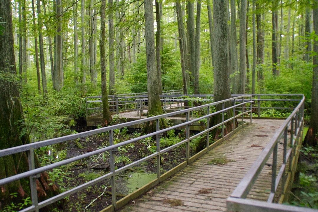
You can find multiple walking trails in the Cache River Basin. (Dean Klinkenberg)
The Upper Cache River isn’t a good option for paddlers, as downed trees often obstruct the stream and the channel is often too shallow. However, the Lower Cache River is a different story, which is why you’ll find a designated canoe trail. The lazy paddle winds through cypress swamps and down the main channel, with helpful signs pointing you in the right direction. The most common route is a little over 3 miles, which is easy to finish in a couple of hours, even if you have little paddling experience. Cache Bayou Outfitters offers canoe and kayak rentals, as well as guided tours of the Lower Cache. If you brought your own boat, you can use the boat ramp at the Lower Cache Access off Perks Road.
The lower end of Tunnel Hill State Trail (see May/June 2024) passes by many of these sights. The paved bike path follows an old railroad right-of-way for 45 miles between Karnak and Harrisburg. At Karnak, a short spur provides access to the Barkhausen Wetlands Center and Cache River State Natural Area.
National Wildlife Refuge
Cypress Creek National Wildlife Refuge is the other main conservation area along the Cache River. It covers 16,000 acres in the Lower Cache watershed. Some of its protected areas are along the east bank of the Mississippi River. It’s a relatively new refuge, established in 1990, so restoration is ongoing. Some areas are closed to the public or not especially accessible, but there are a couple of places worth visiting.
The trail at Limekiln Springs offers a close encounter with the swamps and forests of the Cache River Basin. The 2.5-mile path passes through floodplain forests and by bubbling springs. You can hike across a couple of boardwalks for a closer look at the swamps. Just north of the Lower Cache Access on Perks Road, the Hickory Bottoms Trail loops for about a mile through an older floodplain forest.
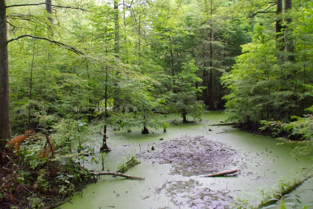
The Cache River Basin has plenty of cypress trees. (Dean Klinkenberg)
Eating and Sleeping
The Cache River cuts through a lightly populated part of rural Southern Illinois. Aside from a couple of small-town cafés, your options include Sawyer’s Subs near Karnak, which makes good sandwiches. There are also a couple of wineries within an hour, at least one of which serves food.
While I’ve gone down to the Cache River and back in a day, I prefer to stay overnight, so I have more time to relax and explore. There’s no camping in the state natural area or federal refuge, but Ferne Clyffe State Park and Fort Massac State Park are within 30 miles and offer full-service campgrounds. The scenic (and large) sites at Trail of Tears State Forest are also within a half-hour drive of the Cache River. They come with outhouses but no other services.
If you prefer to sleep in someplace more substantial than a tent, a few private vendors rent cabins or rooms in the area. Perkins House Inn, for example, rents 14 rooms in a historic hotel in downtown Vienna, just a few miles from Heron Pond. The tourism office for Southernmost Illinois keeps a current list of what’s available.
Southern Illinois continues to surprise me with its varied land and waterscapes. The Cache River Basin might have the most variety in any single area I’ve encountered, and it’s all within an easy drive of St. Louis. I plan on making this area a regular stop on my visits to Southern Illinois, to go deeper into its extraordinary world, and I hope you will, too.
Author: Dean Klinkenberg is a frequent contributor to Terrain.
Top image: Courtesy of Dean Klinkenberg.
Leave A Comment