
Welcome to a rollercoaster ride of stellar rock formations, of the high-bluffed Buffalo River, of scores of fun streams and creek crossings, of bustling cities and historic towns, and of views with seemingly millions of trees in all shades of summer green. And, come fall, in a full rainbow of colors. You’re going to love it. Well, as long as you like to climb.
This is the Arkansas High Country Route, the newest long-distance option conceived by the Adventure Cycling Association (ACA). The ARHCR, as it’s called for short, is a challenging route of three interconnecting loops totaling almost 1,200 miles in length; roughly half the roads are paved, the other half dirt and gravel, including an optional 67 miles of single-track.
The route goes up and down and winds around two major mountain ranges in the northwest and north-central parts of Arkansas: the Ozarks and the Ouachita (WASH-ah-taw). To put some numbers to it, the lowest elevation of the ARHCR is a bit above 200 feet. The highest? More than 12 times that at over 2,500. Plus, hundreds of climbs and hundreds of descents in between.
Also between the lofty Ozark and Ouachita peaks lies one of the nation’s greatest rivers, its headwaters in Colorado and its mouth almost 1,500 miles downstream: the Arkansas River. In its wide, green valley you’ll be able to rest your weary legs. (I rested mine longer than intended last summer when finding part of the route flooded as I neared Little Rock. Some kind folks on the north bank let me spread my maps out on the hood of their car and showed me how to avoid the wet.)
If you’re already a biker tourer, then you know that route changes can be required for any number of reasons. But with this trail of little paved roads and sometimes littler, twisting, gravel paths, creative workarounds become part of the challenge. And part of the fun — if you’ve got the right attitude. And enough food.

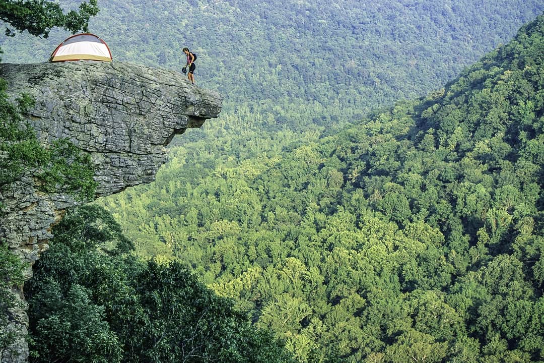
Cyclists in Steel Creek region of Upper Buffalo Wilderness Area in northwest Arkansas. (Dennis Coello)
Before any more blather, I must tip my bike helmet to a schoolteacher named Chuck Campbell, the architect of the ARHCR. The story goes that a few years back he was griping to himself that Arkansas was not part of ACA’s nearly 50,000 miles of mapped routes across the country.
Me, I’d have griped and gotten over it in seconds, and the year-old route wouldn’t exist today. But Campbell, thankfully, is a different kind of guy. He went from being bummed to doing something about it, writing to the ACA headquarters in Montana and telling them of all they were missing.
And they listened! Campbell was asked to sketch out a course of great views and interesting places, all along roads where riders weren’t sure to get creamed. He got to work, and so did the ACA. With backing from the nonprofit as well as from the Arkansas Parks & Recreation Foundation and the Walton Foundation, Campbell was hired to spend a couple years poring over maps and driving his proposed route.
There must have been thousands of emails between him and the ACA’s cartography team, the folks responsible for the detailed, waterproof, foldout maps of the ARHCR. In tiny print, there’s a library’s worth of information — what services you’ll find in towns along the way, elevation graphs, and many important notes about “Remote Riding Conditions”.
The last are not the take-a-jacket-it-might-rain refrains we all remember from our mothers. This is serious stuff. Fail to pack enough grub, deplete your water supply without a purifier in your panniers, or fail to consider how really tough some gravel roads can be on your bike and your body, and you could be parched, hungry, and broken down long before you reach that next stopover.
But don’t let those words discourage you, because the ARHCR also has something going for it that many long-distance cycling routes lack (in addition to its mix of paved and unpaved roads, that is). Take a glance at the map. What do you see? Loops!
Most long bike tours are point-to-point. We somehow get ourselves and our bike and gear to the starting spot and back again at the end of the ride. I don’t know about you, but I’ve been bike touring since 1965 — yes, before even some of your parents were born — and getting to and from the route is sometimes the hardest part.
The ARHCR, however, is a circle, or rather circles, so you can end where you started, on whichever of the three interconnecting loops is closest to where you live. (I prefer to stash my car, something I did on six trips down and back last year, and found it waiting for me every time; Campbell suggests flying into Little Rock and starting from there.)

Speaking of bikes, it appears the days of road bikes for pavement and mountain bikes for all the rest are history. We’re now in the age of gravel bikes, beauties with racing bike geometry but wider tires, allowing you to zoom along on pavement and on the kinds of gravel roads always pictured in gravel bike ads.
The ACA maps discuss which bikes might be best if one intends to ride the entirety of the roughly 50/50, paved/unpaved route. The Salsa Warbird is mentioned, and having visited the brand’s website, I can say, Lord, but they’re pretty!
Personally, I’d love to borrow one and spend a month making my slow way around the entire route in one shot, in contrast to my half-dozen trips last year with my usual setup for long miles: 20-year-old touring bike, racks front and rear, with 1.5-inch tires (at present the Schwalbe Marathon Plus; they’re heavy, but almost never a flat).
My bike handled a lot of the gravel roads well, but in thick dust and recently re-graveled sections I had to push. It wasn’t often, and I was packing a lot of weight in my saddlebags. On pavement, I flew along.
The ACA maps also state, “Those who choose comfort over speed will elect for full suspension or fat tires to pad the ride.” Really? Pedal fat tires over all that pavement? I guess it beats hiking. The sweet lady I often use as a model preferred her mountain bike on the gravel, and she didn’t have to work as hard as I did when things got steep. But she dogged it when we finally hit a stretch of pavement.
So, use the excellent ACA map info to help you choose a loop, or a piece of one, that fits the number of days you’ve got free. Or choose overnight out-and-backs along pieces of them — my favorite for long, weekend trips.
There’s also a bounty of information you can find online about pedaling this route, including one lengthy and excellent article by Chuck Campbell titled “What’s So Special About the Arkansas High Country Route?” Who could possibly answer that question better than him? Another good article is by a female racer who was the first to buzz her way along the entire route. I’ve never been bitten by the bug to see the world as a blur, but I sure do have respect for those who train so hard to do so.
And there are more fun pieces you can find about the “first annual” Arkansaw High Country Race, with comments about locals in little towns embracing the riders with smiles, hurrahs, food, and even places to catch some shuteye.

Cyclist on CR 1425 south of Eureka Springs, Arkansas. (Dennis Coello)
But back to options for a moment, for I want to say something about the state of Arkansas at large. Even though it’s one of the eight bordering Missouri, I’d pedaled none of it before clipping a corner corning home from a world ride in ’74. Next came an enticing north-south slice when riding the length of the Mississippi River, and years after that a lot of two-wheeled research when following the route of the Spanish explorer Hernando de Soto, whose 300 men tramped all over Arkansas in 1541. Think of that — the Spanish clanking along in their armor, back and forth, searching for gold, almost half a thousand years ago.
And here’s something else to ponder while pedaling: We envision colonial Lexington and Concord and tri-corner hats when hearing of the American Revolution, but its westernmost battle was fought in…wait for it…Arkansas!
On an exploration of the ARHCR, you’ll be riding over each of the three major Trail of Tears routes, as they converged to enter the old “Indian Territory” of Oklahoma.
And who knows that nearly 200,000 African American troops fought for their freedom in the Union Army, many hundreds of them in the bloody Civil War battles of Jenkins Ferry and Poison Springs? The people of this state do, even if they didn’t learn it in school, for year after year there are reenactments of those battles, blacks and whites in Union blue and Confederates in butternut.
You can time your rides, as I sometimes do, to coincide with these reenactments, a chance to talk with these “experiential historians” who not only read all the books but learn what it felt like to hike and hunt for fellow humans with the weapons and gear of the 1860s.
So much for my quick lowdown on the ARHCR. Come for quiet mornings of coffee outside your tent at French-named mountaintops you scaled the evening before and for laughs with the locals at springtime daffodil festivals and Ozark autumn fairs. Or time your arrival so you can watch mountain bike racers fly their way through pretty downtown Bentonville.
I did that, last fall, and the next morning saddled up with a hundred others for a fun morning ride into the hills. It means a lot when an entire state seems to go out of its way to say welcome to its two-wheeled visitors.
Be Prepared!
In an interview last June with Zoie Clift of the Arkansas Department of Parks & Tourism, Chuck Campbell spoke about the South Loop of the Arkansas High Country Route in particular, but his wise warnings fit all three loops. I provide them here as a reminder to plan ahead:
“…services are few and far between.” The opposite is true in some places, of course, especially on the 36-mile Razorback Regional Greenway linking Bentonville, Springdale, and Fayetteville in the Northwest Loop.
“Be happy if you complete 75 percent of the mileage you had first expected.” Read this slowly, twice, and think about what it means you should pack. Sure, weight sucks — until it’s exactly what you need when you’re riding hard but still many miles from a town or planned rendezvous.
“Be ready to see bears in early summer.” Yikes! Lucky for us most bruins don’t wake up each day hoping to munch on a biker. Still, be careful you don’t bump into one around a blind curve or get between a furry mother and her cub. I pack parachute cord to suspend my food 10 feet off the ground when camping. And, uh, don’t hang it next to your tent.
“…be ready to traverse some very rocky roads that eat bike tires.” Racers have to worry about this more than us slower riders, who can pick our way through rockier sections of gravel roads. Nevertheless, tube repair kits, a couple spare tubes, the ability to boot a tire, and a trusty pump or air cartridges are a must.
Author: Dennis Coello is a contributor to Terrain Magazine.
Photos: By Denis Coello.
Leave A Comment