
We’ve logged a lot of miles while making this magazine, and as we continue to celebrate a decade of publishing Terrain in 2024, we thought it would be fun (and informative) to look back at some of our favorite hikes. Along with insight from our contributors, we drew inspiration from local experts and five years of Readers’ Choice Awards. And so, in no particular order, here are 10 “peak paths” for hiking close to our hometown of St. Louis.
Trail Through Time
Distance: 2 miles
Location: Pickle Springs Natural Area (New Offenburg, Mo.)
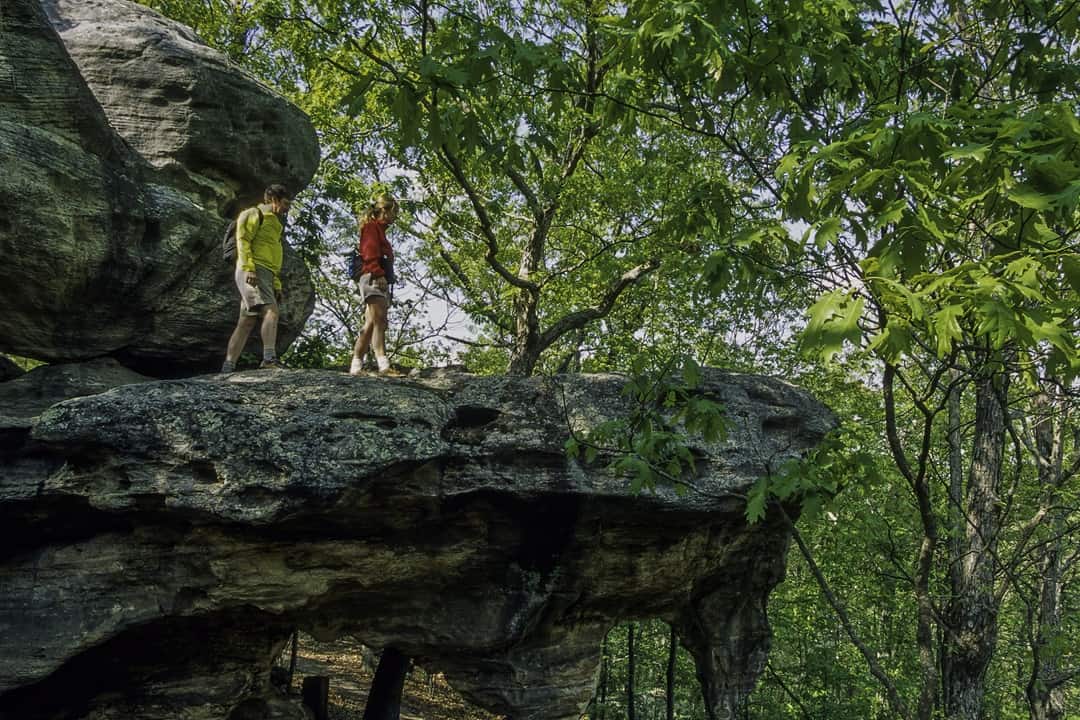
I hiked this trail with my daughters in about 90 minutes, the slower-than-average pace based mainly on our stopping so many times to look at the incredible rock formations. There were arches and narrows and boulders (oh my!) in addition to creek crossings and a bluff overlook. This is a moderately strenuous hike but a must-see in my book. Note that, as the trail falls in a natural area, dogs are not allowed.
Ozark Trail
Distance: 430 miles
Location: Missouri Ozarks
We’ve written a lot about the Ozark Trail over the years, and for good reason. It’s a regional treasure and will be even more so once its 13 sections are connected. It presently offers trips from a few miles to 230, so spend an afternoon on the Taum Sauk Section visiting Mina Sauk Falls or a week backpacking along the Eleven Point and Current River sections. Keep in mind this is a remote and wonderfully pristine trail with limited services. Plan accordingly.
Green Rock Trail
Distance: 14.5 miles
Location: Rockwoods Reservation, Greensfelder County Park, Rockwoods Range (Wildwood, Mo.)
There aren’t many hiking trails in St. Louis County that stretch 14.5 miles point to point. But Green Rock does. I walked it in one outing — meandering through three park and conservation areas — and ended up with the sore quads to prove it. There’s almost never a minute where the trail is flat; it’s always rolling (sometimes climbing) up or down. But boy, is it serene and beautiful. Remember to drop a car at the end of the trail, or you’re in for 29 miles round-trip.
Lewis & Clark Trail
Distance: 13.5 miles
Location: Weldon Spring Conservation Area (Weldon Spring, Mo.)
This two-in-one, intermediate trail was the featured destination in our last issue. Often called out as having some of the best overlooks around, the path soars over the Missouri River and offers undulating blufftop and bottomland environments. Two segments add up to roughly a half-marathon distance but can be shortened to an 8.2-mile (Lewis) or 5.3-mile loop (Clark) for a more relaxed outing. Head to nearby Defiance for a local beer or wine afterward.
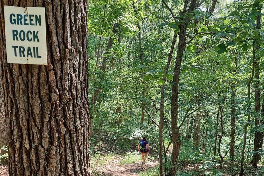
Green Rock Trail in Rockwoods Reservation. (Brad Kovach)
Grotpeter Trail
Distance: 4.25 miles
Location: Castlewood State Park (Ballwin, Mo.)
River Scene Trail gets a lot of fanfare for its birds-eye views of the Meramec River, but our readers named Grotpeter their go-to at Castlewood State Park. The beginner-friendly trail rises slowly as it follows the crest of a ridge around the perimeter of the park, then comes back down to Kiefer Creek and the valley in which the parking area is located. Speaking of which, if you choose to go on a nice weekend, get there early or be prepared for significant traffic.
Chubb Trail
Distance: 6.5 miles
Location: West Tyson County Park (Eureka, Mo.)
This rugged point-to-point route has one trailhead at West Tyson County Park and another at Lone Elk Park. Starting from the former, you’ll encounter a rocky, rooty ascent to a hilltop picnic table before a sustained descent and then a smooth hike alongside the Meramec River. The Lone Elk end has a short but steep groomed climb to the parking lot. Chubb is also popular for mountain biking, so keep your eyes open for other trail users.
Goat Cliff Trail
Distance: 1.5 miles
Location: Pere Marquette State Park (Grafton, Ill.)
I’ve hiked this doublewide path a few times, and the climb up from the visitor center parking lot is no joke. Along the way, you’ll encounter striking rock formations — sharp boulders jutting from the ground like giant teeth. You’ll also cross the Cap au Gres Fault Line and pass by springs gushing out from underground. The trail ends at McAdams Peak, where you can gaze over the Missouri, Mississippi, and Illinois rivers and (hopefully) spot bald eagles in wintertime.
Buford Mountain Forest Trail
Distance: 9.4 miles
Location: Buford Mountain Conservation Area (Bismarck, Mo.)
Lesser-known than some of the other trails listed here, Buford Mountain is a great day-hike destination from St. Louis. The namesake trail climbs up and around the mountain’s five peaks, culminating with sweeping views across the Belleview Valley from 1,740 feet above sea level. The rolling hills are densely forested. Due to the elevation gains, this trail isn’t rated for beginners; pack lots of water and wear sturdy boots.
Old Stoneface Trail in Shawnee National Forest. (Brad Kovach)
Zombie Trail
Distance: 6.15 miles
Location: Bluff View Trail System (Wildwood, Mo.)
Now part of the larger Bluff View Trail System (9.5 miles total), Zombie is a moderately strenuous loop that weaves along both sides of paved Rock Hollow Trail. The natural-surface path features some of the most scenic rock formations and ravines along any trail in St. Louis County. Highlights include a wet weather waterfall in a cave-like depression on the west side and a series of hand-built stone switchbacks and a rock “chute” on the east side.
Old Stoneface Trail
Distance: 1.6 miles
Location: Shawnee National Forest (Harrisburg, Ill..)
The capper of this outing is a photo opp with Old Stoneface, a cliffside rock feature that resembles an old man, but the rest of the trail deserves your attention, too. In a scant 1.6 miles, it ascends through the base of a bluff with fascinating pockets and ledges, then cuts back to the top of the escarpment after crossing a striking, moss-covered rock slide. You’ll pass several overlooks before reaching the main attraction. Say cheese!
Author: Brad Kovach is the founder and publisher of Terrain Magazine. Additional reporting provided by Nick Tilley.
Top Image: Trail Through Time in Pickle Springs Natural Area. (Dennis Coello)
Leave A Comment