
Riding a bike or walking across a bridge can feel a bit unnerving. Cars and trucks careen past you, spraying gravel, dirt and other bits of road refuse, leaving you feeling quite literally as if you’ve been left in the dust.
Bridge sidewalks are often cracked, curbs broken. The car lanes on bridges seem narrower than normal, even though they’re not. And then there’s the noise. The roar of engines and the whirring of tires on the bridge reverberate over the water below, magnifying the sound exponentially.
The oppressiveness of this sensory experience — visual, auditory and physical — often puts pedestrians and cyclists in one mindset: to get across the bridge as soon as possible.
The beauty of the river you’re crossing is most certainly lost.
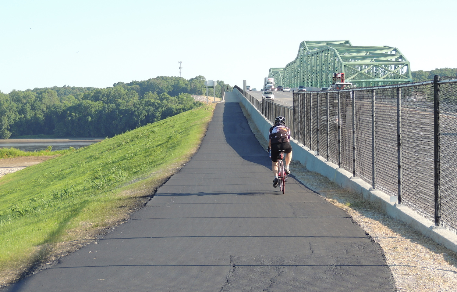
Thankfully, this is not the case with the new eastbound Daniel Boone Bridge on 1-64/US 40. The bridge, which crosses the Missouri River at Chesterfield, was opened to vehicle traffic in 2015, and a bike and pedestrian path opened in June 2016. The path is wide enough for two-way bike traffic and is protected from cars and trucks by a 3- to 4-foot-tall concrete wall topped off with about 3 feet of thick metal mesh.
Although the noise is still there, the traffic barrier provides such a strong sense of security that the casual walker or biker can feel free to do what vehicle passengers routinely do: enjoy the view!
And, oh, what a view. Traveling west from Chesterfield, you’ll go past the lush flood plains that lead inevitably to the serene but powerful Missouri River. Limestone bluffs stand tall on the west bank, gleaming brightly on a sunny day, revealing their craggy surfaces on an overcast day.
After crossing the river, and actually enjoying it, you’ll find yourself experiencing Missouri’s most famous biking and walking trail: Katy Trail State Park. On this part of the trail, near the bridge, you’re enveloped in a quiet, tree-lined canopy as you travel the former railroad right-of-way.
Go south, and you’ll soon come upon the well-loved locales that attract so many people to the region: Defiance, Matson, Augusta, Dutzow. Longer rides take you to Marthasville and Hermann, and beyond. Wineries, breweries, antique stores and cafes beckon along the way.
Or go north at the bridge and you’re on your way to Old St. Charles and its charming riverfront park and cobblestone streets. There’s no shortage of eats and libations, plus sightseeing and the occasional festival.
Either way, you’ll feel miles away from the suburbs. Not that we don’t like suburbs — but, heck, it’s sure nice to get away from the house and the yard work to experience nature and small-town Americana. And, now, it’s easier than ever.
It’s All About Connections
The significance of the new, shared bike/pedestrian lane on the Daniel Boone Bridge cannot be overstated. Now, for the first time, people can walk, run or bike to the Katy Trail from neighborhoods in Chesterfield, via the Monarch Chesterfield Levee Trail and the trails that connect to it.
Bridge access opens up a whole lot of opportunities for hikers and bikers, as well as merchants and restaurant owners on both sides of the river. The economic impact remains to be seen, but with the increasing popularity of cycling, it’s safe to assume that as more people try out the bikeway on the Daniel Boone Bridge, more money will be spent on everything from outdoor accessories to wine.
It was more than just coincidence that brought the Monarch and Katy together. Ralph Pfremmer, CEO of Trailnet, says the City of Chesterfield has long championed the building of paved pathways to connect walkers and riders to recreational and nature-based destinations.
“Chesterfield has done an amazing job of developing trails and creating a walkable, livable community,” Pfremmer said. “They’ve really invested in the community.”
Dan Hurt, longtime councilman in Chesterfield, says that the vision for a connected trail system goes back to the city’s founding in 1988. Surveys of residents in the early 1990s showed strong support for traditional parks as well as trails, so the city decided to do a mixture of the two.
Now, with access to the Katy Trail, Hurt says even more people can take advantage of the connecting trails. “The main benefit to these trails is health. This will encourage a healthy population on both sides of the river — St. Charles and Chesterfield,” he said.
To draw attention to the new bike lane on the Daniel Boone Bridge, Trailnet organized a two-day bike trip in October, called Magnificent Missouri, which started and ended at the Monarch Trail near St. Louis Premium Outlets. It took participants all the way to Hermann via the Katy.
“The more we can get these trails connected, the more people will want to access them,” Pfremmer said. “The Boone Bridge is a great example of connecting people from one county to another, from one side of a river to the other, with no worries about navigating traffic.”
With easier access, outdoor enthusiasts can focus on what they appreciate the most: the scenery and the journey.
The Monarch Chesterfield Levee Trail
This 10.4-mile, smooth, asphalt trail was built on top of an embankment that protects Chesterfield from flooding of the Missouri River. The path is wide and mostly flat, and offers scenic views of the river in some areas.
The trail begins near the Howell Island Conservation Area, a forested area popular for bird watching, fishing and hiking, then travels east through open grassland, making its way to Chesterfield Valley and providing access to the Daniel Boone Bridge.
Three segments of the trail will eventually connect for a 17-mile loop. A 5.5-mile segment is now complete from the Hardee’s Ice Rink to the Chesterfield Valley Athletic Club and over the Missouri River to connect with the Katy Trail. You can also follow the trail in the other direction to Centaur Road. A two-mile segment is also complete from Long Road to Baxter Road.
A southern section of the trail running next to Bonhomme Creek will eventually meet the main trail at the ice rink.
Planning and design for the Monarch trail began in 2006, and construction started in 2008 on the first phase. Funding sources included Great Rivers Greenway, which is a taxpayer-funded agency, as well as the Chesterfield Valley Transportation Development District and the City of Chesterfield also provided funding.
A Brief Bridge History
The new bike and pedestrian pathway on the Daniel Boone Bridge was the last step in a $111 million Missouri Department of Transportation (MoDOT) project. The first step was to replace the 80-year-old westbound span of the bridge, which was not designed for interstate-level traffic and had reached a point where it needed regular preventative maintenance.
The old westbound bridge had three narrow lanes (with no shoulders) that often got congested during peak travel times. To replace it, MoDOT built a new bridge upstream from the existing spans in 2015. The new bridge has four 12-foot lanes, shoulders and a bicycle trail.
Following this new construction, crews rehabbed the 1989 eastbound span and converted it to carry westbound traffic. It reopened in late 2015. The old westbound span, which opened in 1937, was demolished in early 2016.
Author: Terri Waters is a freelance writer based in St. Louis.
Photo: Courtesy of Missouri Department of Transportation.
Leave A Comment