It’s hard to overestimate the impact that Katy Trail State Park has had on our state. At one time, the 240-mile-long corridor stretching from Clinton, Kan., to St. Louis — and further into other states — sat idle and dilapidated, a remnant of the Missouri-Kansas-Texas (MKT) Railroad. But that all changed in 1990, when the first two sections of the public-use Katy Trail opened from Rocheport to McBain and from Augusta to Defiance. Today, according to the Missouri State Parks, some 400,000 Katy Trail visitors generate $18.5 million for our state each year. The “skinny park” has been nominated for (and won) numerous awards that recognize outstanding recreational opportunities and is a member of the Rails-to-Trails Conservancy’s Hall of Fame. Not bad for a 25-year-old vagabond.
Description
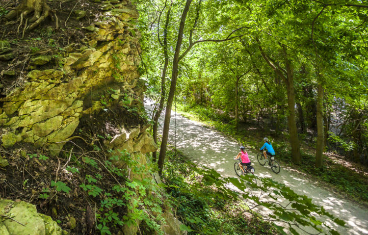
Whether you’re interested in a half-hour stroll or a six-day, cross-state bike ride, Missouri River bluffs or open fields, primitive campsites or quaint towns, the Katy Trail has the diversity to keep you coming back. Designed for hikers and bicyclists, the trail also allows horseback riding in certain areas (see mostateparks.com for details).
The park is open from sunrise to sunset, 365 days a year, and is marked every mile with a signpost corresponding to the original railroad mileage system. Keep track of your progress by noting the mile number at the trailhead and the mile number on the trail, and subtracting.
The Katy is primarily an 8-foot-wide pathway topped with crushed limestone, providing the opportunity for “gravel grinding” even when the weather has soured your other outdoor plans. Area mountain bikers use the Katy as a “spine” to access several St. Charles county parks located along its route, including Lost Valley, Matson Hill and Klondike. Similarly, cyclists and hikers use the trail to get from town to town during multiday adventures.
Trailheads extending from St. Charles all the way to Clinton offer services including grocery/snack stores, restaurants, bike rental/service, camping, lodging and restrooms. Signs typically indicate the services provided at each trailhead or community; because hours of service vary and some businesses are seasonal, it’s always a good idea to call ahead.
Certain businesses, including Katy Trail Rentals (katybikerental.com) in Defiance and Show Me MO Tours (showmemotours.com) in St. Louis offer a shuttle service for hikers and cyclists using the Katy Trail. In addition, the trail is host to numerous events each year, including the Katy Trail Ride (mostateparks.com/2015-katy-trail-ride), a weeklong tour with full support and frequent stops, and the Midwest Active Katy80 (katy80.com) and GO! Missouri KT82 (gostlouis.org), popular team relay runs.
History
When the MKT railroad ceased operation in 1986, the Department of Natural Resources acquired the railroad right-of-way through a 1983 amendment to the National Trails System Act. In 1987, the department was issued a “certificate of interim trail use” to begin using the corridor as a recreational trail.
That same year, businessman Edward D. (Ted) Jones and his wife Pat, both supporters of the rails-to-trails concept, donated $200,000 to the Conservation Federation of Missouri Charitable Trust to be used to acquire the railroad right-of-way. The Jones subsequently donated an additional $2 million for construction of the trail from Machens to Sedalia.
The first section of the trail opened in April 1990 between Rocheport and McBaine. In August of 1990, another section from Augusta to just northeast of Defiance opened. The rail corridor from St. Charles to just past Sedalia was developed by 1996. Through a donation from the Union Pacific Railroad, the department then extended the trail to Clinton, opening the section between Sedalia and Clinton in September of 1999. The last 12-mile section between St. Charles and Machens was opened in 2011, completing the 240-mile Katy Trail.
Trail Information
Length: 240 miles
Type: Linear
Surface: Crushed Limestone
Rating: Easy
Best for: Biking, Hiking, Running
Parking: (Near St. Louis) Page Bridge lot; Creve Coeur Park; St. Charles Trailhead Frontier Park Trailhead; Greens Bottom Road Trailhead; Weldon Spring Trailhead
Amenities: There are restrooms at many of the trailheads, as well as towns along the trail offering water, restaurants, groceries or vending machines; other amenities include bike shops/rental facilities, museums, bed and breakfasts, and wineries
Author: Doug Simmons is a regular contributor to Terrain magazine
Leave A Comment