
St. Louis has always been a city at the crossroads. It lies at the confluence of the Mississippi, Missouri, and Illinois rivers and is a critical part of our nation’s inland marine and railway transportation industries. Historically speaking, it’s where the East ended the West began and was a fault line between the North and South during the Civil War.
The Mississippi Greenway, also known as North Riverfront Trail, which stretches 11 miles along the Mississippi River starting downtown and heading north, reflects St. Louis’ unique geography and also serves as a record of its progress.
Description
The old Laclede Power Co. building stands guard at the entrance of the paved trail at Biddle Street. The trailhead here connects to historic Laclede’s Landing and Eads Bridge on the south end, allowing easy access from the Laclede’s Landing/Eads Bridge Metrolink Station.
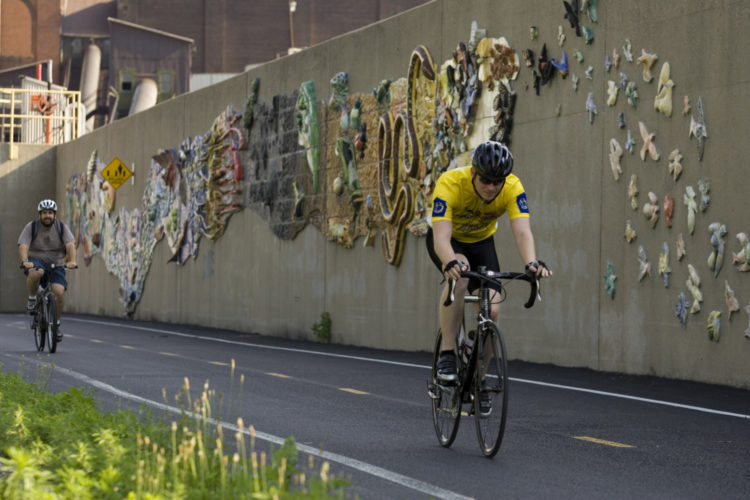
From the Laclede edifice, which is being renovated for shops and a scenic overlook, the pathway follows the floodwall with 190-foot-long “Reflections of the River” art mural and provides unparalleled views of the Mississippi from the top of the levee. This is a working river, and if some of the sites are warehouses, elevators, conveyors, and scrap yards, then it only serves to provide contrast and perspective.
The trail runs past numerous historic places, including the Mary Meachum Freedom Crossing (the first nationally designated Underground Railroad Site in Missouri, just three miles north of downtown), and skirts the edges of long-standing neighborhoods such as Baden, College Hill, Hyde Park, and Old North St. Louis.
Maline Creek and North Riverfront Park, with restrooms, drinking fountains, and also a stocked lake and boat ramp, make good waypoints along the route. Another park, Chain of Rocks Park, has picturesque bluffs leading to the Old Chain of Rocks Bridge, part of the legendary Route 66. Traveling across will connect you with the Madison County Confluence Trail, which can take you all the way to Alton via its network.
History
In 1988, the North Riverfront Trail laid the foundation for local trail building when Trailnet was founded to promote it. Since then, the non-profit health and active-living organization has partnered in the development of many other trails including Grant’s Trail, West Alton Trail, East St. Louis Heritage Trail and the Metro-East Levee Trail.
Trailnet was also a leading partner in the conversion of the Old Chain of Rocks and Eads bridges to accommodate bicycle and pedestrian use. The lease on the Old Chain of Rocks Bridge was transferred to Great Rivers Greenway in January of this year, and this group currently maintains the bridge along with the Mississippi Greenway in partnership with the City of St. Louis. This greenway is part of the overall network that Great Rivers Greenway, the regional parks and trails district, is building to connect St. Louis City, St. Louis County, and St. Charles County.
In September, Great Rivers Greenway’s construction on Leonor K. Sullivan — the street between the Gateway Arch grounds and the river — will extend the path south from the Biddle Street trailhead all the way to Chouteau Avenue, making it 12.5 miles long and adding a separated walking path as well.
Directions
There are multiple parking areas from which you can access the greenway. These include the trailhead adjacent to the Laclede building on Biddle Street, the Mary Meachum Freedom Crossing site, North Riverfront Park, and Old Chain of Rocks Bridge Park.
More information on the trail is available at greatriversgreenway.org.
Trail Information
Length: 10.8 miles
Type: Linear
Surface: Asphalt
Rating: Easy
Best for: Biking, Walking, Running, Rollerblading
Parking: Biddle Street parking lot; North Riverfront Park; Laclede’s Landing/Eads Bridge Metrolink Station; Chain of Rocks Bridge parking lot (Ill.)
Amenities: There are portable restrooms at the Mary Meachum Freedom Crossing site, adjacent to the Old Chain of Rocks Bridge, and at North Riverside Park
Author: Brad Kovach is the editor of Terrain magazine
Leave A Comment