
Tales of strange incidents and ghostly apparitions on “Zombie Road” have existed ever since its creation in the late 1860s. The original dirt and gravel path was carved out of thick trees and brush to provide access to the Meramec and the railroad tracks located along the river. One legend says the phantom of an early settler who was struck and killed by a train haunts the dark forest. Another describes a killer who lived in a dilapidated shack by the water and who would attack young lovers who came there looking for privacy.
There’s still a lot of buzz about the old road even today, although now it’s because the surrounding woods are home to one of the region’s premier multi-use trails. Built by Gateway Off-Road Cyclists (GORC) over the past several years, Zombie Trail weaves among the high hills on both sides of the road — now paved and called Rock Hollow Trail — providing a happy playground for hikers, runners, mountain bikers and equestrians.
Description
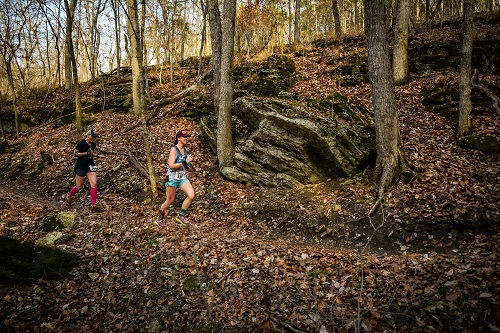
The 100-percent, natural-surface pathway located in Wildwood, Missouri, currently measures 6.15 miles and features some of the most scenic rock formations, waterfalls, springs and ravines along any trail in the greater St. Louis area.
Starting at the Trailhead of the Undead — yes, that’s its real name — the single-track climbs up the western ridge line, twisting and turning through dense forest before eventually evening out and hugging the moss-covered bluff. From there, “Zombie West” offers smooth, fast trail with a few punchy climbs and sharp turns leading into and out of gullies. The only noteworthy obstacle on this half of the trail is a series of shelf rocks that demand attention for a short span.
The highlights of Zombie West include a couple of creek crossings and two trickling waterfalls: one the you cross on top after ascending a short rise and the other that you pass under, stepping behind it into a cave-like depression. In winter, the latter waterfall can freeze, creating a floating column of jagged ice.
Once you drop down to the pavement, the route continues on the other side of Rock Hollow Trail with a short, steep climb back up to the ridge line. “Zombie East” is distinguished by epic rock formations scattered along the undulating trail — stout boulders and sharp bluffs that heave into view all around the path. GORC has done an amazing job of incorporating these natural features into the routing; nowhere more so than on a series of hand-built stone switchbacks that mount a ravine midway through this half of the trail.
Other hallmarks of Zombie East: a rock “chute” that you travel through and several dirt berms that mountain bikers in particular enjoy swooping down. No wonder this trail is fast becoming the go-to for local backwoods riders.
Future Plans
Zombie Trail currently ends where its southeast tip meets the blacktop of Rock Hollow Trail, by which users can access other paths such as the Al Foster (see Sept/Oct 2017) and Bluff View (see Spring 2015) trails. It’s even possible to venture all the way to Castlewood State Park in Ballwin and to Greensfelder County Park in Eureka with a little creative routing.
By the end of this year, GORC plans to have finished the remaining .25 miles of work necessary to connect Zombie West with Zombie East on the south end, making the trail a true loop. Once officially complete, the trail will be renamed Bluff View Trail and will include the current 2.5 miles of Bluff View as well as the Rock Hollow Connector for a total mileage of about 9.5 miles.
With its variety of terrain, striking scenery and access to other nearby outdoor assets, Zombie Trail has nearly everything you could want in an off-road destination. The scariest thing you’re likely to encounter these days? A screaming good time.
Trail Information
Length: 6.15 miles
Type: Loop
Surface: Natural
Rating: Intermediate
Usage: Running, hiking, bicycling, equestrian
Parking: Available at the Grand Avenue parking lot in Glencoe, Mo.
Amenities: Access to the Al Foster, Rock Hollow and Bluff View trails
Author: Brad Kovach is the editor/publisher of Terrain Magazine.
Image: Rick Mayo/Mile 90 Photography
There is also a ROCKY HOLLOW PARK in Missouri. The town is EXCELSIOR SPRINGS, MO.
ABOUT 25 MILES FROM KANSAS CITY,MO. It isn’t haunted tho. Family-friendly, picnics,
ball diamonds. Long ago they would have gas powered boat races.
[…] this profile in Terrain Mag for some spooky history. I have yet to find a close trailhead parking for it – I parked 2 […]
[…] Halloween Ghost Story: Zombie Road Profile: Zombie/Rock Hollow Trail in Wildwood, Missouri […]