
The Mississippi River Water Trail offers paddlers a depth of cultural and outdoor experiences that are hard to match along the Father of Waters (so named by Algonkian-speaking Native Americans). You can paddle the waterscape that inspired Sam Clemens to become Mark Twain. Eagles and American white pelicans grace the sky. Paddlers can float through the confluence of the two biggest rivers in North America. And there’s not a more dramatic place to end a paddle than the 150-year-old cobblestone levee at the foot of the Gateway Arch.
Paddling the Mississippi might be one of the most underappreciated experiences in the region. It’s a completely different vibe than floating down an Ozark stream. While it also takes more preparation, the historic river towns, wildlife, and splendid isolation will hook you and keep you coming back.
Why Paddle the Mississippi River Water Trail?
“All of the natural elements that you go away to these wilderness areas to experience, you can experience on this river locally,” said “Big Muddy” Mike Clark. “It’s a completely unique ecosystem.” Few people know the Mississippi River as well as Clark, who has paddled every mile of it and has been leading guided canoe tours the Mississippi with Big Muddy Adventures on since 2002.
The Mississippi River, in spite of our attempts to engineer its wildness away, offers a collection of diverse habitats that support a wide range of wildlife, birds especially. When you travel it in a canoe, kayak, or stand-up paddleboard (SUP), you’re going slow enough to take in the details of the riparian world around you. Gliding along quietly, you get closer to wildlife than you could in any other boat.

The Mississippi River at River Mile 217-214.
“It’s absolutely never the same,” said Eileen Lenkman, who has paddled the Mississippi many times. Water levels change, which exposes or covers islands and floodplain forests. The way the light illuminates the river changes throughout the day and seasons. As a major migration corridor, you’ll see different animals at different times of year.
And all that wilderness is easily accessible. “You don’t have to drive far to be somewhere where there are no people,” said Dave Haessing, president of the St. Louis Canoe & Kayak Club.
The enormity of the Mississippi is also part of the attraction. “By sheer size, you are getting a challenge unlike any other river,” according to Clark. “It’s not that adrenaline rush that running whitewater is, but the challenges are inherent in a body that size.”
How to Paddle the Mississippi River
You don’t have to be an expert paddler to take a trip on the Mississippi, but if you’re a beginner, you’ll want to start out with someone who knows what they’re doing. Even if you’re comfortable with your paddling skills, there are a few things to consider in advance.
“If you’re going to be out in the middle of the river, you need to be able to self-rescue, or if you’re out with a group, to assist them,” advised Joan Twillman, president of the Mississippi River Water Trail Association. Every paddler I talked with emphasized self-rescue skills. If you don’t know what that means, then you’re not ready to paddle the Mississippi on your own. Take a safety course first to learn the basics of what to do if you fall out of your boat.

Paddling the Mississippi River along Calhoun County in Illinois. (Tanner Aljets)
Big rivers require bigger boats: at least 14 feet for a kayak or 16 feet for a canoe. Everyone in your boat should be wearing a type III life jacket. There are no exceptions to this rule. Bring ropes. If you don’t tie up your boat when you stop, you may be swimming to retrieve it.
Bring a spare paddle and pack some food and water. Put sensitive items like electronics in a dry bag. Wear a hat and cover exposed skin with sunscreen. Wear clothes appropriate for the weather (cotton isn’t recommended). The American Canoe Association recommends additional thermal layers if you’re paddling on days when the combined air and water temperate is below 120 degrees. The water in the Mississippi can be surprisingly cold into early summer, so you may need to wear a wet or dry suit early or late in the season. Good boots are indispensable.
Check the weather and wind speed before you leave. “Depending on the way the wind is blowing, you can end up in some pretty impressive waves,” Twillman said. Besides that, strong headwinds make paddling a lot harder, so you may want to wait for a calmer day. Plan a route and tell someone who isn’t with you where you’ll be, then let them know when you expect to be off the river.
Learn the rules of the river and how to interact with barges. “A barge can’t stop quickly, and it probably can’t see you,” said Haessig. Steer clear of places with heavy recreational boat traffic, like Dardenne Slough on weekends. Keep a safe distance from structures that can mess with the current, like bridge piers.
The paddlers I talked with agreed there’s no good reason for recreational paddlers to travel through the Port of St. Louis, especially downriver of the Arch. The river is clogged with barges, the current tricky, and there’s no place to take out if you run into trouble.
Above all, remember that paddling on the Mississippi is a time to slow down, to put aside distractions, and set your internal clock to river time. Put your phone in a dry bag and, if you have to multi-task, split your attention between paddling and watching the world around you.
Where to Paddle on the Water Trail
It’s possible to take a short paddle through backwater habitats, a longer tour that includes a stop in a river town, or some combination of the two. Several routes are described on the Mississippi River Water Trail website, which also suggests places to put in and take out. It’s easy to design a paddling trip for just a couple of hours or across several days. Paddling a loop route is a good option if you need to start and end from the same access point.
While the Water Trail officially begins at Lock and Dam 22 at Saverton, Missouri, Hannibal, 8 miles upriver of the dam, is also a good starting point. Paddlers can explore the Twain attractions in town, then paddle past three islands that make up the remnants of Huckleberry Finn’s Jackson’s Island.
The historic cities of Louisiana and Clarksville, Missouri, are easy to reach from the river and just 10 river miles apart. Each offers places to eat and shops operated by local artisans. Grafton and Alton, Illinois, offer more dining and entertainment options, with a 15-mile paddle connecting them. Paddlers can put in or take out at the Piasa Creek Access to cut the trip in half. Keep in mind that the area around Grafton and Alton can be clogged with recreational boaters on weekends.
The Water Trail passes through two impressive confluences. Just upriver of Grafton, the Illinois River merges with the Mississippi, creating lush islands and sandbars that attract wildlife and humans looking for a place to relax. One way to explore it is by paddling a loop route from Grafton.

Paddling on the Mississippi River near Grafton, Illinois. (Eileen Lenkman)
South of Alton, the Missouri merges with the Mississippi, creating a turbulent, roiling current. Duck Island and the backchannel on its west side are often rife with birds. Recent flooding has taken a toll on Colombia Bottoms Conservation Area, which offered the best access for paddlers. Until that is restored, paddlers interested in a trip through the Confluence could begin at either the Maple Island access below the Mel Price Lock and Dam or the boat ramp at Colombia Bottoms, then take out above the Chain of Rocks or North Riverfront Park. The route from Maple Island to North Riverfront Park is about 12 miles.
Just past the Confluence, paddlers enter the only stretch of barge-free river between St. Paul and the Gulf of Mexico. “I think it’s the great American paddling route; there’s nothing like it on this river,” Clark said.
This section includes two structures that look like small castles rising above the water. The buildings disguise water intake structures that were built in the 19th century, a time when people thought something as humdrum as a water intake structure should look beautiful. Just below them, the Chain of Rocks runs from bank to bank. It’s possible to paddle over the Chain, but whether and how to do it will depend on your paddling skills and how high the river is. (See the sidebar for tips.)
Some routes along the Water Trail require passing through a lock. It’s free and straightforward, but you should prepare yourself by reviewing tips on how best to navigate them. A Google search will turn up many good tutorials.
Other good options for paddling a loop route include a circumnavigation of Cuivre Island (downriver of Winfield, Missouri) or Pohlman Slough at the southern end of Calhoun County, Illinois. Ellis Bay at Riverlands Migratory Bird Sanctuary is a good place to paddle around if you’re looking for an easy, introductory paddle, plus you can tour the Audubon Center while you’re there. Access to Ellis Bay is restricted at times to protect migrating waterfowl. Pohlman Slough should be avoided during duck hunting season.
Twillman also recommends the 5-mile paddle from Sherwood Harbor in St. Charles County to Hideaway Harbor as a good introductory route, where it’s easy to stay close to shore if you want.
The length and accessibility of the river also make it a great place for a long-distance trip across multiple days. Many islands are open to camping, and the Water Trail includes 17 designated (primitive) campsites.
Want to learn more? Check out the sidebar at the bottom of this page. Even better, participate in a paddling event sponsored by the Water Trail or the St. Louis Canoe & Kayak Club. You’ll learn first-hand from people with experience on the river.
What are you waiting for?
Paddling the Chain of Rocks

In the 1950s, the Army Corps of Engineers built a low-head dam and a canal so commercial boats could bypass the rapids known as the Chain of Rocks. (Paddlers should avoid the canal.) The rapids still pose a significant obstruction for paddlers. The decision about whether to paddle over them or portage around them will depend on the river level (based on the St. Louis gauge) and a paddler’s experience.
Above 24 feet, it’s generally a smooth ride over the Chain. Between 16 and 24 feet, experienced paddlers will usually find a path through, but paddlers with no experience in rapids should portage.
If you want to paddle over the Chain, Mike Clark advises that you pull ashore on the Illinois bank to scout the run: “I would say that to any paddler of any level of expertise in the world when you get to the Chain. Stop. Get out. Walk up and look at that Chain to find the line of water that allows you to go through, and that there’s no obstruction there.”
All paddlers should portage via the Illinois shoreline if the river is below 16 feet. When you put back in, North Riverfront Park will be your last chance to take out until you are near the Arch. Check out the Mississippi River Water Trail Association website at mississippiriverwatertrail.org/trips/chain-of-rocks for more detail.
Learn More
The Mississippi River Water Trail Association (MRWTA) was established to partner with the Army Corps of Engineers to foster appreciation of the Mississippi River through recreation, with a focus on paddling sports and the 121 miles from Lock and Dam 22 to St. Louis. It organizes paddling and educational events to address that mission. See its website for maps and more ideas about where to paddle. mississippiriverwatertrail.org
The St. Louis Canoe & Kayak Club supports canoe and kayak activities, trips, and educational programs. The Club promotes safe and ethical use of our waterways. Other projects include helping to keep our waterways clean and providing skills clinics through the year. Membership is open to anyone interested in canoeing and kayaking for $20 a year. If you’re not a member, there’s a $5 fee to go on a club trip. stlcanoekayak.com
Author: Dean Klinkenberg is a contributor to Terrain Magazine.
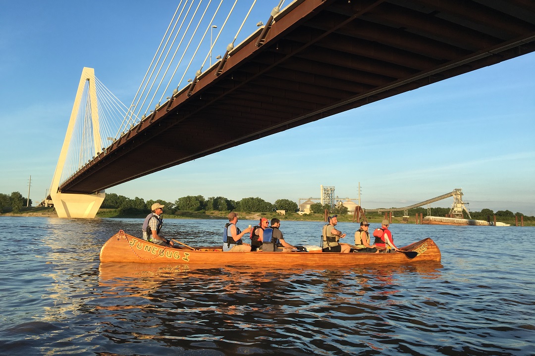
Featured Image: Mike Clark (left) guiding a crew of Big Muddy Adventures passengers under the Stan Span.
Leave A Comment