The area where the Missouri and Mississippi rivers meet, what many of us know as the Confluence, is a special place. It’s a dynamic location, where the waters have reshaped the land for perhaps millions of years. It attracts — and has long attracted — generations of visitors.
Trumpeter swans paddle by as bald eagles swoop from the sky. Lewis and Clark set off on their epic journey up the Missouri from here. Steamboats rest deep beneath the soil, buried under the silt conveyor belts that are the two biggest rivers in North America.
Farmers and industrialists have tried to control the Confluence to suit their needs, but the mighty waterways keep making that difficult. In 1993, record flooding transformed the surrounding acreage into a body of water expansive enough to be a sixth Great Lake. One unexpected result of all the flooding was that much of the property around the Confluence eventually became public.
Today, flooding is again forcing changes around the Confluence. The persistent high water of 2019 had the most dramatic impact, but the reality is that the lands here have been flooding more often than anyone expected. The two largest public areas — Jones-Confluence Point State Park and Columbia Bottom Conservation Area — have been forced to close at times, and their stewards are rethinking how best to manage them sustainably while keeping them accessible to the public. Here’s a look at how that process is coming along.
Jones-Confluence Point State Park
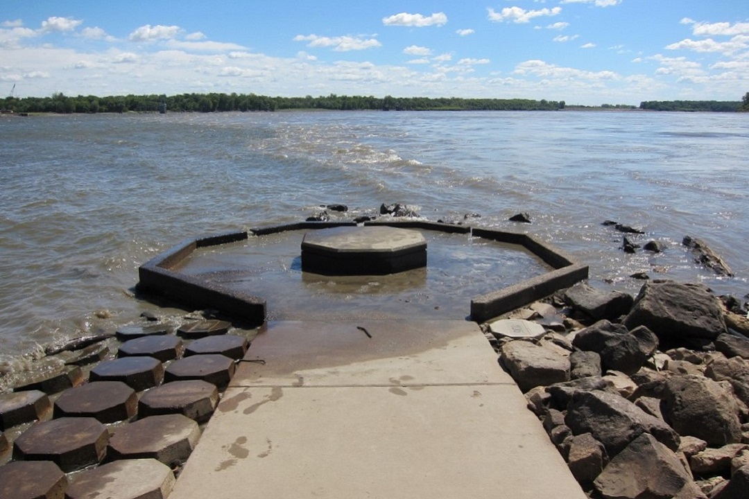
There’s no better place to get up close and personal with the Confluence than at Edward “Ted” and Pat Jones-Confluence Point State Park. Since the park opened in 2004, visitors have been able to walk down a narrow peninsula and experience the two big rivers around them. Since 2007, though, high water has topped the 7-mile-long Kuhs agricultural levee six times, forcing extended closures of the park.

Frequent flooding at Jones-Confluence State Park has caused closure and expensive cleanups. (Dean Klinkenberg)
“We completely knew that [flooding] was going to be a regular practice, so that didn’t deter us any,” said Park Superintendent Quinn Kellner, “but the frequency has been more abundant than we were counting on.”
The initial plan of the Missouri Department of Natural Resources (DNR) emphasized restoring the wet prairies that once were common in the area — and are now nearly extinct in Missouri — along with bottomland hardwood forests. In order to avoid expensive post-flood cleanups and to protect the views of the rivers, minimal development was proposed.
But the frequent floods have created unexpected challenges. The concrete path to the Confluence had to be replaced with crushed rock. In addition, the 2019 flood dropped a lot of sediment that can only be cleared with the heavy equipment that DNR properties around the state share. Because of the pandemic, the park’s wait for that equipment has been much longer than usual, which is why the park has yet to reopen.
The list of work still to be completed includes removing debris and layers of silt; repairing erosion along the path to the Confluence; cleaning the viewing area, bathrooms, and educational kiosks; restoring the parking area; and rebuilding part of the access road.
Kellner is hopeful the park will reopen in spring 2021. Meanwhile, ecosystem restoration is continuing, and Kellner is developing plans to install viewing blinds around the Confluence, so visitors can more easily observe birds without disturbing them. The park may also add new walking trails, and Kellner is looking at options for better connecting trails between the state park and nearby Riverlands Migratory Bird Sanctuary and the Audubon Center at Riverlands.
Columbia Bottom Conservation Area
When the City of St. Louis purchased Columbia Bottoms in the 1940s, it eyed the property as a site for a second airport. Thankfully, that didn’t work out, and in 1997, the City sold the land to the Missouri Department of Conservation (MDC).
MDC envisioned an urban conservation area that would accommodate multiple public uses, including hunting, fishing, hiking, biking, and wildlife observation. As with Jones-Confluence Point State Park, though, the main attraction is the view of the Confluence. MDC built a platform overlooking the rivers, which is a short walk from a parking lot, picnic shelter, and bathrooms.
Like the state park across the river, flooding has taken a toll.

Debris caused by flooding at Columbia Bottom Conservation Area. (Dean Klinkenberg)
The mile-long road from the levee to the Confluence viewing area has been closed since 2019 because of heavy sediment deposits. The rivers dumped large trees around the viewing platform and piles of sediment cover much of the parking lot and bathrooms. The high water poked several holes in a levee, which accommodated a trail for biking and hiking. Portions of the paved road to the boat ramp washed out.
After a few adjustments, Columbia Bottom reopened in spring 2020, although it’s a bit more work to get around. Boaters can once again reach the ramp on the Missouri River, but only by following a roundabout path. The Confluence viewing area is accessible, but visitors must park in Lot L and walk the 2-mile round trip to get there, passing through an area that is reverting to a more natural state. The trails are closed, though bikers and hikers can still use the roads. Unfortunately, access for paddlers is essentially unusable most of the time.
“When we have one of these major flood events, it takes us a long time to get back to the point that we were,” said Gary Calvert, regional resource management supervisor for MDC’s St. Louis Region. “It’s not year for year or month for month. It may take us two or three or four years to get back to stage one before floods.”
What does all this mean for the future of Columbia Bottom? They don’t know yet, beyond a commitment to keep it open.
“Columbia Bottom has still got a bright future. It’s not going to get sold,” Calvert emphasized. “The area is still going to be managed, but it may be managed in a different way than it has been in the past.”
MDC is currently reassessing its management plan for Columbia Bottom to account for more frequent flooding. Just about everything is on the table, including what to do about the viewing area, whether or not to repair the levee, and what a sustainable trail system might look like. Stay tuned.
Adjacent Areas
While Jones-Confluence Point and Columba Bottom are the largest public spaces at the Confluence, they aren’t the only ones. Lewis & Clark State Historic Site manages a small area across the Mississippi from Columbia Bottom with a nice view of the Confluence. This site has housed a memorial to the Lewis and Clark expedition since the 1950s. Like other sites, silt and trees deposited by high water pose the biggest obstacles to reopening after floods.

Riverland Migratory Bird Sanctuary at sunrise. (Great Rivers & Routes)
Flooding is causing a similar re-evaluation process at the Army Corps of Engineers, which manages 48,000 acres of land in the St. Louis District. One of the biggest areas it manages is Riverlands Migratory Bird Sanctuary, which is adjacent to Jones-Confluence Point. One of the big projects at Riverlands has been to restore the tallgrass prairies that once dominated the area, prairies that existed because Native American communities used fire to manage the landscape. Those tallgrass prairies took a big hit from the 2019 flooding, and it will take a while for them to come back.
Maintaining public lands where two major rivers come together is a challenging task that requires constant evaluation and adjustment. Perhaps now more than ever, we’re lucky we have so many different ways to enjoy the Confluence — and land managers dedicated to keeping it a special place.
Author: Dean Klinkenberg is a contributor to Terrain Magazine.
Leave A Comment