Closely study a map of the Ozarks and you might notice something interesting. Across this vast region of rugged highlands and twisting rivers, the same place names appear repeatedly. It might happen with town names like Salem or Eureka, which are commonly found in dozens of states all across the country. But in the Ozarks, the naming repetitions are more often related to flowing water. And sometimes these repetitions occur so close to one another, they happen within the same county or watershed. For example, there are numerous Big Creeks, Muddy Creeks, and Shoal Creeks.
This connection to water makes sense because the Ozarks have what geologists call karst topography. Essentially, falling rain and melting snow filters into the mostly limestone bedrock, which dissolves into sinkholes, caves, and underground rivers. Due to the Ozarks’ undulating terrain, this pervasive subterranean water flow will often burst out of the ground in certain spots, resulting in the abundant freshwater springs that feed Ozarks streams.
In fact, there are so many springs, it seems there just weren’t enough names to go around. All across the region, you’ll find numerous Big Springs, Boiling Springs, Round Springs, Cave Springs, and Ebb and Flow Springs. Whatever you do, don’t try to navigate around the Ozarks using the words Blue Spring. You’ll drive in more circles than families trying to find parking on a Saturday at the St. Louis Zoo.
The name repetitions might explain why the Ozarks sometimes feel smaller than they actually are. But 50,000 square miles is no joke. The Ozarks are the same size as the state of Louisiana or Greece (the country, not the bacon fat that some paddlers use to make grease bombs). The Ozarks span four states, with two-thirds in Missouri, a quarter in Arkansas, and the rest mostly in Oklahoma, plus a sliver in Kansas. The result is that sometimes two paddlers might think they are discussing one river, when each is actually referring to a completely different waterway.
For instance, there are two Big Pineys in the Ozarks, yet many people believe there’s only one. Big Piney River is a lush float stream in the northern Ozarks near Rolla, Missouri. Big Piney Creek is a whitewater river (go figure?) in the southern Ozarks of Arkansas. For sake of convenience, let’s call the Missouri one BPR and the Arkansas one BPC.
In 1992, about 45 miles of BPC were added to the National Wild & Scenic Rivers system — the longest of seven such designations in the state. Both BPR and BPC are great paddling runs, and each is worth experiencing. But when conditions are right, BPC in Arkansas stands out as one of finest paddling destinations in the entire Ozarks. Let’s discuss.
Big Piney River in Missouri
For most paddlers around the Missouri side of the Ozarks, the Big Piney they think about is BPR, just west of Rolla. One of the best sections is the 7 miles of Class I-II from Sand Shoals to Boiling Spring. The river is more like a creek in this upper reach. As you progress, the channel becomes more river-like as the volume increases from many inflowing springs. Riverside bluffs are topped by pines and broadleaf trees, which often overhang the water, making for a well-shaded run that’s perfect for hot summer days. At take-out you can further cool off in the tub-like Boiling Springs. Afterward, stop by the Piney River Brewing Co. in the nearby town of Bucyrus (see our September/October 2019 for an article on the brewery).
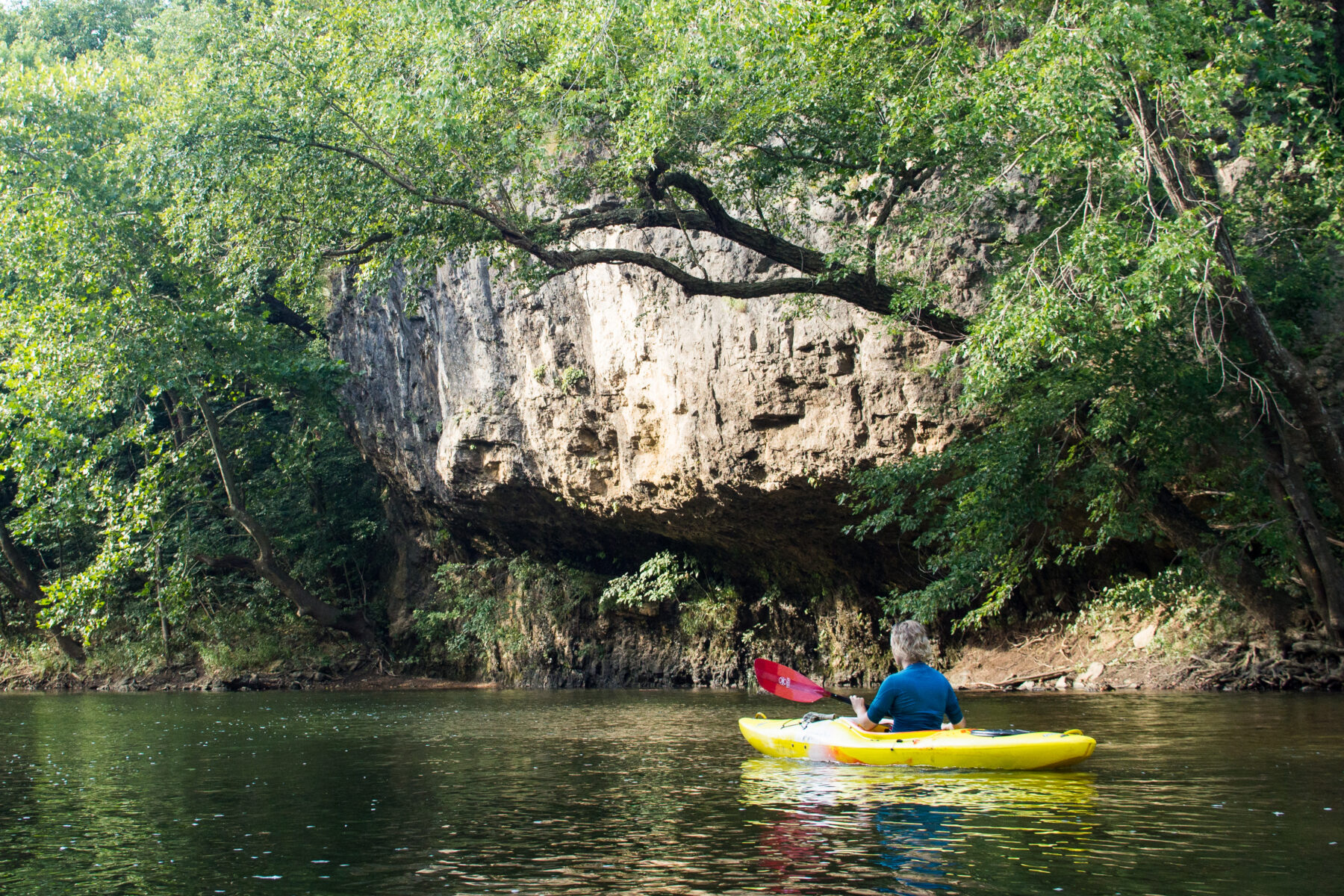
Rocky bluff on Big Piney River in Missouri. (Mike Bezemek)
If you’re looking for a longer day on the river, you can start paddling at Mineral Springs Ford, about 5 miles above Sand Shoals, though this upper reach can be scrapey in drier years. Or you can paddle many sections downstream from Boiling Spring. The added flow makes the river wider, deeper, and sometimes slower in places. Eventually BPR dumps into the Gasconade River, which has plenty to paddle itself, including a stretch with its own — you guessed it — Boiling Spring.
Big Piney Creek in Arkansas
Years ago, I was driving shuttle during my first visit to Big Piney Creek in Arkansas when I slammed on the brakes. A friend and I walked out to a viewpoint and gazed down on a remarkable scene: a deeply entrenched river valley, downright canyon-like, making a sweeping meander through rugged hills. The landscape was somewhat reminiscent of the upper Buffalo River, particularly the bluff-lined meanders in the Ponca Wilderness. But BPC was also different, like a piece of Appalachia had been dropped into northern Arkansas. Morning mists drifted above the river, with its blue waters broken by the white froth of rapids.
Things only got better at river level, where we encountered frequent ledge drops, wave trains, and play spots. Massive sandstone boulders reminded me of Big South Fork on the Cumberland River. In places, cliffs of siltstone and limestone rose above the channel, topped by forests of pine and hardwoods. We fell in with two experienced canoers, among the very few paddlers we saw on a perfect weekend in early June. They pointed us up a side creek where we found a mossy alcove with a plummeting waterfall.
That I’d be going back to BPC was never in question. But when I returned north and tried to rally other paddlers to come with, most seemed unconvinced. Some assumed I was talking about Big Piney River near Rolla, not Big Piney Creek. When I told other folks during later travels around the country, they’d say things like, “Never been to Arkansas cause there’s nothing there.” Funny how people think they know the most about the places they know the least. Their loss, I thought with a shrug. So, I went back to Arkansas to run the river with my wife or on my own.
Why Was BPC Mostly Forgotten?
One time, while I was floating in an eddy at the whitewater park in Siloam Springs, Arkansas, I struck up a conversation with an old timer about paddling in the Ozarks. While talking about favorite runs, I mentioned Big Piney Creek and my surprise at how empty it can be. He loved it, too, and explained that decades ago BPC was a go-to Class II+ whitewater run in Ozarks.
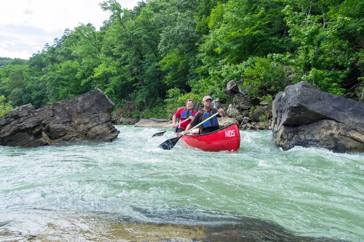
Canoeing Big Piney Creek in Arkansas. (Mike Bezemek)
Spring weekends, he said, saw the pine-forested Long Pool Campground packed with boater vehicles and colorful kayaks. But as skills and equipment improved, whitewater paddlers slowly migrated to other runs across the region. In Arkansas, the hub became the Cossatot River in the Ouachita Mountains. More advanced creekers went to Richland Creek. In Missouri, the St. Francis River was already established as the hub.
While BPC remained well-known among Arkansas boaters, particularly as a great place for beginners, the heyday and social scene that attracted paddlers from the wider region was over. To those paddlers who lived further away, yet remained within striking distance, BPC became a somewhat forgotten relic. A gorge that now sees more in-over-their-heads floaters in rental canoes than whitewater enthusiasts looking for another worthy run to add to the rotation.
A Favorite Day on the Classic Section of BPC
The first snake caught me off guard. It zipped across the surface of Big Piney Creek so fast that I almost felt mildly offended, like I had just floated up to a river party and everyone immediately left. Then two more black water snakes sped across the river, going the other direction, and I was no longer upset about them not sticking around to chat. Please continue your commute there, impatient snakes, I thought. Don’t stop on my account.
I was paddling a solo trip on BPC, the classic 8-mile whitewater section from Helton’s Farm to camp at Long Pool Recreation Area. It was a sunny morning in mid-May, and I was marveling that BPC exists at all. A Wild & Scenic River in the middle of the country, with milky blue water, forest-topped cliffs, and frequent class II-II+ rapids, plus a fun class III called Mother Rapid.
At some point, a fourth snake crossed the river. This one was a huge cottonmouth, aka water moccasin. It swam aggressively on top of the surface, like it owned the place. No argument here. The wildlife show didn’t end there, which helped make this my favorite day yet at BPC. I soon encountered a bewildered fox who stopped drinking from an eddy to stare at me, like it was judging my brightly colored kayaking kit as overkill. Next came two soaring raptors and three paddlers, sitting in a small raft perched onshore.
After returning to camp, my wife and I continued with an afternoon run down the lower section. This run is four miles of class II with plenty of shoals and riffles. We saw exactly two kayakers, who were on shore having what some call a “safety meeting.” My wife took an inflatable, and I took a paddleboard. She had a great run. I fell in a few times and don’t really want to talk about that part of the day.
Afterward, we walked from the take-out to the store at local outfitter Moore Outdoors, which offers shuttles, guided trips, and rental boats. We talked to one of the springtime employees who was also a western raft guide. Once Big Piney dried up each year, typically in early June, he would head out for whitewater season on the Payette in Idaho.
Later, we were packing up the truck at the take-out, when that same dude drove his van across the bridge, heading up-river for a quick lap. He honked and waved, and we waved back. But he must have forgotten something at the store? Moments later, he re-crossed the bridge going the other direction, once again waving and honking.
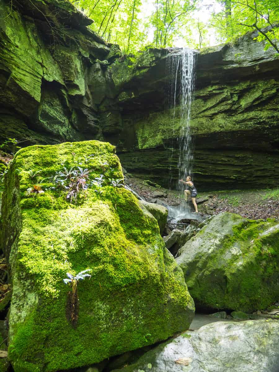
Big Piney Creek waterfall. (Mike Bezemek)
After paddling four runs and twenty miles in two days, my arms were feeling a bit tired when the raft guide loudly drove across the bridge for a third time. But who am I to leave a fellow boater hanging? I waved back once again.
Full disclosure, my enthusiasm was running low when I guess he forgot something else? Because here he came back for a fourth crossing! I did not wave back. But I will say that the fifth time he crossed that bridge, honking and hollering with undiminished enthusiasm, on his way to the put-in, my attitude changed. I was pretty much ready to hop in that dude’s van and join him wherever the hilarious and circuitous ride might lead, whether Idaho or beyond. And should the van find its way back to Big Piney Creek every spring? Well, that would be just fine with me.
When to Paddle BPC?
Big Piney Creek in Arkansas just feels like a bigger river. It reminds me of some smaller rivers found in regions with more topographic relief, such as the Appalachians or wetter watersheds in Northwestern California or Southwestern Oregon. Because the streambed is so wide, whitewater paddlers will want higher levels than typical for the Ozarks. You can get down many Ozark float streams at lower levels, such as a few hundred CFS (cubic feet per second). That definitely works at the narrower BPR in Missouri, which is almost always runnable from inflowing springs. And, yes, you could certainly scrape down BPC in Arkansas at lower flows. But if you’re coming from further away, I recommend a minimum of 1000 CFS for whitewater paddling, as measured by the USGS gauge at Highway 164 near Dover.
While BPC’s typical milky blue color is due to mineral content from freshwater springs, there’s just not enough groundwater flow from the 300+ square-mile watershed to stay running year-round. Thus, the best time to run BPC is in winter or spring after recent storms have spiked the level. Unless you’re an experienced highwater junky, aim for what’s called the falling limb as the flow comes down. Though harder to catch, I prefer going in April, May, and early June, when the foliage has leafed out and the days are longer and warmer. Eventually, BPC will dry out in the heat of summer. But before that happens, conditions may be optimum, for a week to a month, during this late-springtime sweet spot.
Stumbling across a hidden gem like Big Piney Creek, a Wild & Scenic smack in the middle of the country, always makes me wonder. What else might be lurking in these hills? Are there other whitewater creeks just waiting to be paddled? Or hike and huck waterfalls that land in deeply plunging pools? Who knows, maybe you — yes you, reading this article right now — will be the one to find them. When you do, please drop me a line.
Big Difference
Like it or not, the naming situation in the Ozarks is perfectly ripe for a misconception. In addition to having two Big Pineys, there is also a Big Creek and a Big River in the area around the St. Francois Mountains in Missouri. Big River is a moderately moving float stream, with the typical run starting in Washington State Park and continuing for either 3 or 6.5 miles. The main paddling run on Big Creek, however, passes through several shut-ins with sporty Class II whitewater, totaling about 7 miles above Sam A. Baker State Park.
Author: Mike Bezemek is a contributor to Terrain Magazine.
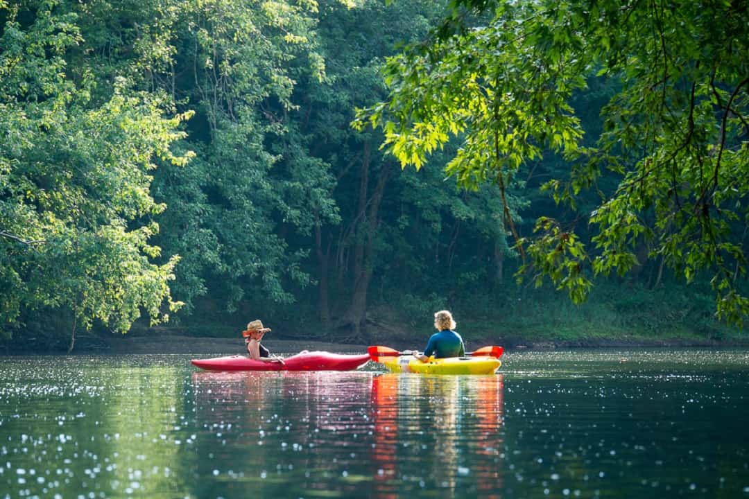
Top Image: Floating on the Big Piney River in Missouri. (Mike Bezemek)
Leave A Comment