
Sparkling clear waters, towering bluffs, sunny gravel bars, and gorgeous scenery abound in the Ozark National Scenic Riverways, the first national park to protect a river system. The Current River and its major tributary, the Jacks Fork, run for 134 miles through the park’s 80,000 acres and are two of the most stunningly beautiful flows in the Midwest. Located in southern Missouri, the area is a paradise for paddling, hiking, camping, and fishing, and preserves some fascinating historical sites.
Six major freshwater springs feed the rivers and keep the water running at 58 to 60 degrees year-round. Big Spring in Van Buren is one of the largest springs in the world, with an average daily flow of 286 million gallons. Three more first-magnitude springs — Blue, Alley, and Welch — each deliver more than 65 million gallons of water daily. The karst landscape of soluble limestone and dolomite rock creates these massive springs, underground streams, and caves.
Both the Current and the Jacks Fork below Alley Spring are floatable all year long. Most riffles are class I, with a few class II spots, making them fun for almost all skill levels. The Jacks Fork above Alley Spring is wilder, and access is limited. It’s best in the spring, when there’s more rainfall.

Alley Spring Grist Mill, built in 1894. (Janice Branham)
There are many good choices for day floats and overnight trips. Covering around 10 miles a day will give you plenty of time to stop and enjoy the sights. If the river is up and you don’t take a lot of breaks, 20 miles is doable in a day. Check the outfitter websites for trip choices or pick up one of the guidebooks below.
The Current River
If the water level is high enough, you can start at Baptist Camp access, otherwise Cedargrove and Akers Ferry are good options.
Three miles before Akers Ferry, Welch Spring pumps 75 million gallons a day into the river. Thomas Welch homesteaded the area in the 1800s. In the 1920s and ’30s, Dr. C.H. Diehl ran a hospital for people with asthma. Patients benefitted from breathing the cool, clean, moist, air from Welch Cave. You can see the hospital ruins near the beautiful spring, the eighth largest in the state.
Cave Spring is halfway between Akers Ferry and Pulltite. A mile north of the spring, off a gravel road from Highway KK, the Devils Well sinkhole drops over 200 feet to a large underground lake that feeds the spring. A spiral staircase descends the sinkhole leading to a view of the lake. A pretty, 4.6-mile loop trail connects Devil’s Well and Cave Spring.
The Pulltite campground at mile 25 makes a great base camp for floats on the Current River. Less than a mile past the campground, Pulltite Spring branch flows in on the right. Accessible only from the water, it’s a shady spot for a cool break. Paddle up to a short trail to see the spring and Pulltite Cabin. The latter was built in 1913 by six men as a vacation retreat; the logs of the Creole-style lodge set vertically to avoid the need to notch them.

Pulltite Cabin on the Current River. (Janice Branham)
Four miles past the spring branch, you’ll come to Current River State Park on the left. Built in the 1930s and ’40s, the park is the former retreat of the Alton Box Board Company. It has lovely hiking trails and two lakes. Park staff offer tours of the historic buildings.
Two miles further, Sinking Creek flows in from the left through Echo Bluff State Park. The creek is warmer than the river and is a nice spot for a swim.
Nine miles below Pulltite, at mile 34, Round Spring is a convenient takeout point for floats on the upper Current. A short path from the parking lot near the lower access leads to the spring.
Below Round Spring, there’s less traffic overall, but you may see some jon boats. Most paddle trips end by Two Rivers at mile 51, where the Jacks Fork flows into the Current. Jet boat traffic increases as you get closer to Van Buren and Big Spring.
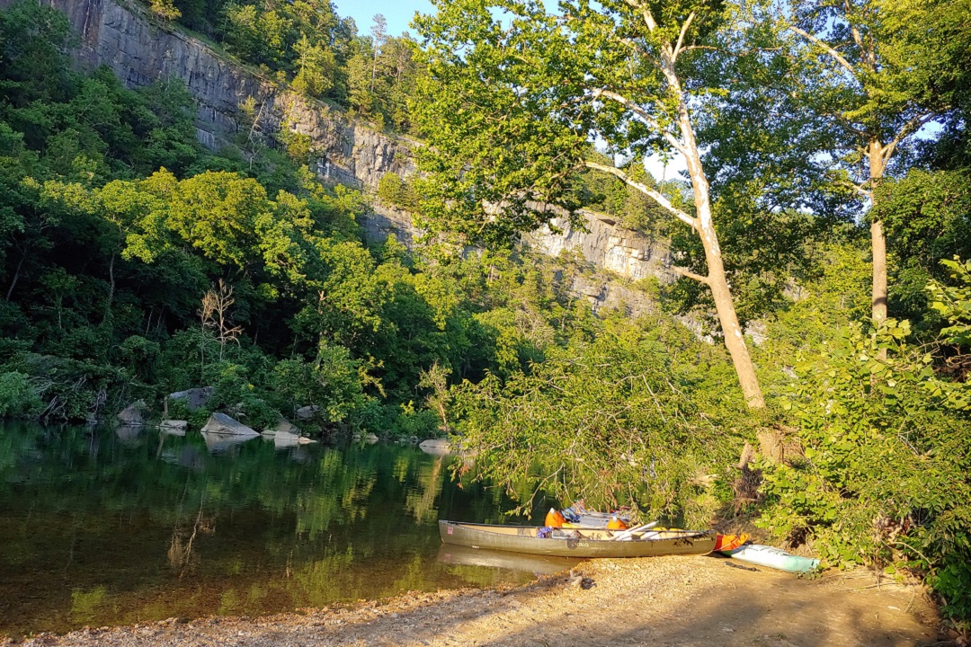
The Jacks Fork
The upper Jacks Fork from the Prongs is wild and incredibly scenic. Limited access has kept it primitive. My husband and I were lucky to be there in May when the water was up. It was a sunny weekday, and we had the river to ourselves for the 18-mile stretch from Buck Hollow to Bay Creek. It’s narrow in places, with some class II rapids that offer plenty of adventure.
Right off the bat, we rounded a bend in the first mile with a good-size tree stump churning up water and a lapful of the cold stuff splashed into my boat. Now and then, we spotted a great blue heron putting on a show.
Six miles in, we came to the 80-foot, cathedral-like archway of Jam Up Cave. The cave is awesome to behold in the natural skylight. Three miles further, Ebb and Flow Spring runs in on the left. Also known as Rymer Spring, it’s a pretty spot to hang out and watch the hawks soaring.

Ebb and Flow Spring on the Jacks Fork River. (Janice Branham)
Alley Spring at mile 31 is the site of a grist mill built in 1894. A community developed around the picturesque structure, with a sawmill, blacksmith, school, and general store. Exhibits in the mill explain the turbine power system and milling process.
The spring charges up the water level below Alley, and the run to Eminence and Two Rivers, at mile 45, is replete with bluffs, rock formations, caves, and wildlife.
Whether you want to zen out on the water, gaze at the natural wonders, or feel the rush of the rapids, it’s hard to beat the Current and the Jacks Fork rivers for enjoying the beautiful Missouri Ozarks.
Trip Tips
Weekdays are best. The rivers get very crowded on summer weekends. Try to go between Monday and Thursday for a more peaceful, socially distant experience.
Check the weather and water levels. Rain can push the water level above flood stage quickly. The National Park Service (NPS) website for the Ozark National Scenic Riverways lists average and flood stage water levels and connects to the USGS Water Resources pages, where you can look up the current water gauge height. If there’s a river closure, NPS usually posts an update by 9 a.m. on their Facebook page for the Ozarks.
Protect the rivers. Please don’t enter any caves or springs in the park. All caves are closed to contain the spread of White Nose Syndrome, which has decimated bat populations. Springs are delicate ecosystems that can harbor plants and animals that don’t live anywhere else. Enjoy the scenery from dry land. Pack out your trash and leave no trace.
No glass. Don’t take any glass bottles within 50 feet of the rivers.
Classes. A paddling class is extremely helpful for learning safety skills and efficient paddling technique. NPS offers free canoe skills classes led by American Canoe Association certified instructors on several Sundays in the summer (check its Facebook page for details). The. St Louis Canoe & Kayak Club will hold a full-day skills clinic July 11 and runs educational programs and trips through the year. The Missouri Whitewater Association and the Alpine Shop also offer classes from time to time; check their websites to see what’s coming up.
Guidebooks. Paddling the Ozarks by Mike Bezemek is an insightful and entertaining guide with detailed descriptions of the rivers, maps, and access points for selected river sections. A Paddler’s Guide to Missouri published by the Missouri Department of Conservation is another excellent planning tool that has complete maps with points of interest and access for each river.
Safety Matters
File a float plan. Leave it with a someone who will expect your return. Include a description of your boat, who is with you, and where and when you expect to arrive.
Always wear a life jacket. It can’t save you if you don’t have it on.
Bottom down, feet first in the water. If your boat capsizes, float facing downstream with your bottom down and your feet up, then work your way to the shore.
Avoid sweepers. Tree branches hanging out in the river can trap or sweep you off the boat. Do you best to avoid them. If you do get swept into one, lean forward and climb up on the obstruction to avoid getting pinned underwater.
Gear Essentials
Be sure to pack sturdy shoes, bug repellent, sunscreen, a hat, and a long-sleeve shirt. The sun is intense on the water. “Prevention is better than a cure,” said Perry Whittaker, a wilderness first responder and lead instructor at the Alpine Shop. He recommends 10 essentials to be prepared for emergencies on all backcountry trips:
- Map and compass. Don’t rely on your cell phone
- Emergency whistle. Attach it to your life jacket and use it to signal for help.
- Extra water. Bring plenty of it, plus water purification tabs or a water filter. Backup water frozen in plastic bottles will help keep your cooler cold.
- Backup food supplies. Pack energy bars in addition to your regular lunch and snacks.
- Rain gear and extra dry clothes. You’ll want these in case of rain or a tumble in the river.
- Lighter or a magnesium fire starter. These are indispensable if you get stuck out overnight.
- First-aid kit. Search online to learn what a standard outdoor kit should include.
- Basic survival tools. A Swiss Army knife or Leatherman, plus a small roll of duct tape.
- A flashlight or headlamp. Two more must-have items in case you get stuck out after dark.
- Emergency shelter. A large trash bag, tarp, bivy sack, or emergency blanket will do.
Author: Janice Branham is a regular contributor to Terrain Magazine.
Featured Image: Chalk Bluff on Jacks Fork River by Janice Branham.
Leave A Comment